
Ben Nevis – Nelson
Did you know that there is more than one Ben Nevis in New Zealand? I discovered this whilst having a cake break half way up Ben Nevis just outside of Nelson. This wonderful day hike of nearly 5 km has an elevation gain of around 800m up Gibbs Spur to the summit. If you’re feeling adventurous and the weather is good, you can continue much further along the (unmarked) ridge route. Experienced trampers could traverse the entire length of the ridge to Mount Ellis, which is part of Te Araroa Trail Richmond alpine crossing. DOC recommend to allow 3.5 hours to the summit, and we made it in roughly 2.5 hours including a 20-minute break.
The Ben Nevis in Mount Richmond Forest Park stands at 1619m. By comparison the one in the Hector mountains near Lake Wakitipu in Otago stands at 2234m. ‘The’ Ben Nevis in Scotland stands at 1345m and is Britain’s highest mountain.
Getting there Ben Nevis
Ben Nevis is about an hour to the South West of Nelson. Take the SH6 South towards Wakefield, then turn left into River Terrace Road at Brightwater. Follow the Wairoa Gorge Road, cross the Wairoa River Right Branch and follow the orange markers/signage. I wasn’t driving, thank goodness. When I read up on the hike beforehand, it mentioned that the road becomes winding and narrow and only suitable for 4WD vehicles – and that was absolutely correct.
My ageing camper van would never have made it up there. The roads are forestry/logging roads, which were mostly well-graded, but near the top, it was very steep and rutted. We didn’t drive the last 250m or so, and instead parked on a little sidling to the right and walked it. If you’re heading out this way, check the roads are open before you come – they may be closed in the week due to logging operations.
Gibbs Spur
The Ben Nevis Track follows Gibbs Spur all the way to the summit and is well-marked. We started at 10.40 am. The first kilometre or so really steep, so be prepared to be huffing and puffing immediately. After the initial 4WD road walk, we headed into an almost dark forest of fir trees.

Once out of the fir trees, there was a more open section of scrub. We walked in the clouds – desperately hoping it would brighten up so we would have good views at the summit!


After a while, we came to a couple of rocky outcrops and there was quite the drop-off to our left. Thankfully the trail was in good shape so it wasn’t anything to challenge my fear of heights. The trail was nicely undulating and entered another beech forest section.

CAKE!!!! Ben Nevis
By midday, about an hour and 20 minutes in, we were back into the open again, but still a little way from the summit. Not that we could see it, the cloud was still swirling all around us. We decided to stop for a break. I had brought lunch, and my hiking buddy had brought ‘surprises’. Goodness! Rich not only baked, but he hauled it up a mountain, with coffee too! This is definitely a gourmet style of tramping that I could really get used to 🙂 The verdict?? The carrot cake was beautifully moist with magnificent icing, and the lemon slice was light, gooey and delicious.

Towards the Summit Ben Nevis
After 20 minutes or so we continued on to the summit. As we were packing up the clouds parted for a brief moment and I caught a glimpse of the ridgeline above us. It was incredible. The trail entered a final section of forest and climbed until we found ourselves in the open at around 1300m with the beautiful ridge ahead of us. We stopped to chat with a couple of parties who were coming down.


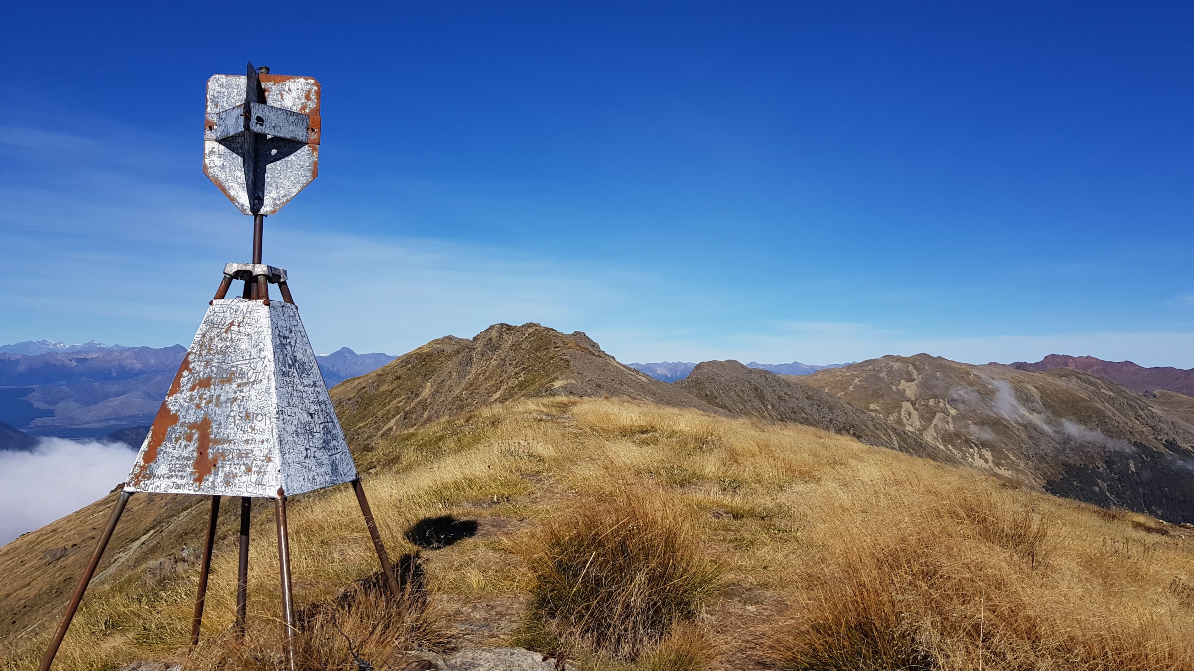
At the summit
We reached the trig at the summit at 1 pm, but as it was such a lovely day, we decided to continue along the ridge. At around 1.30 pm we found a sheltered spot behind a little peak and had lunch. Unfortunately, my hiker lunch of crackers cheese, salami and salad paled in comparison to the lunch ‘surprise’ of pizza… (some thought had obviously gone into the surprises!).

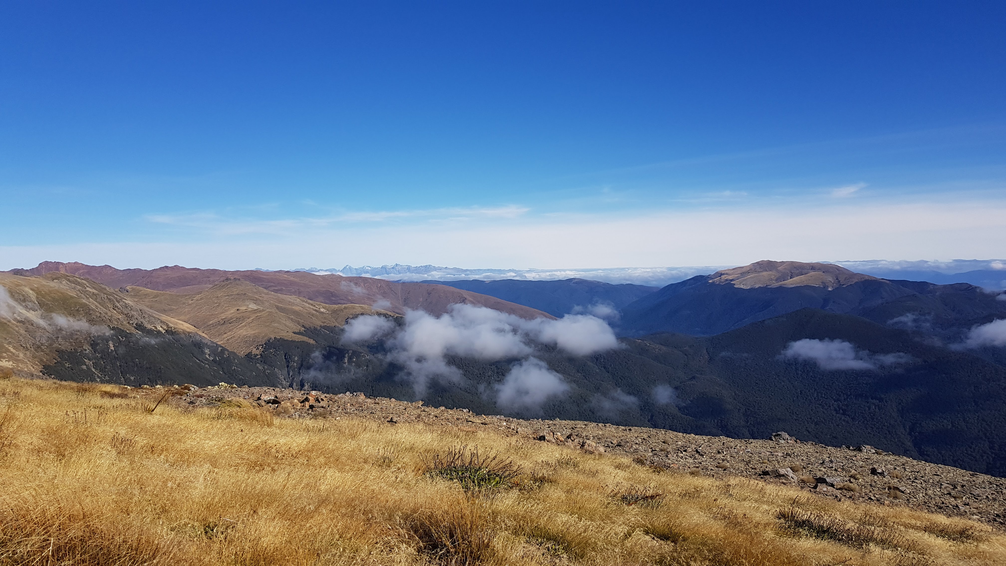
The views from the ridge were incredible! Kahurangi National Park to the west and the Richmond ranges to the East. In the far distance, we could see the snow-capped peak of the Kaikoura ranges.
Following Te Araroa Trail
We could make out the Richmond Ranges alpine route of Te Araroa trail. To our East, when the cloud cleared we could see Mount Starveall. We followed the ridge along and came to the peak and huge scree slope of Mount Rintoul. Then we saw the dome-shaped Purple Tops in front of Rintoul as we looked at it. Following the ridge, in a South West direction, we knew that Tarn hut was just off the other side of it.


The Wairoa River Left Branch was directly below and East of our ridge, and we followed it as far as we could, knowing that it met Mid Wairoa hut. I remembered the beautiful river crossings of the Wairoa River from Mid to Top Wairoa huts, that I hiked on Christmas Eve five months ago.
Finally, further along our ridge, to the South West was Mount Ellis and the huge expanse of the Red Hills beyond. I had hiked over Mount Ellis in absolutely terrible weather on Christmas day! Seeing the Te Araroa route from up here put a whole new perspective on that part of the trail.
Heading back
After 30 minutes or so, and stuffed full of delicious carbs we made our way back along the ridge to the trig. The cloud was just starting to creep over the ridge. It took us around 2 hours 15 minutes to backtrack the way we had come, down to the car.
This would be a fantastic route to come back to in the height of summer to explore the ridge and further.


Great description, fantastic photos, thanks for sharing 🙂