
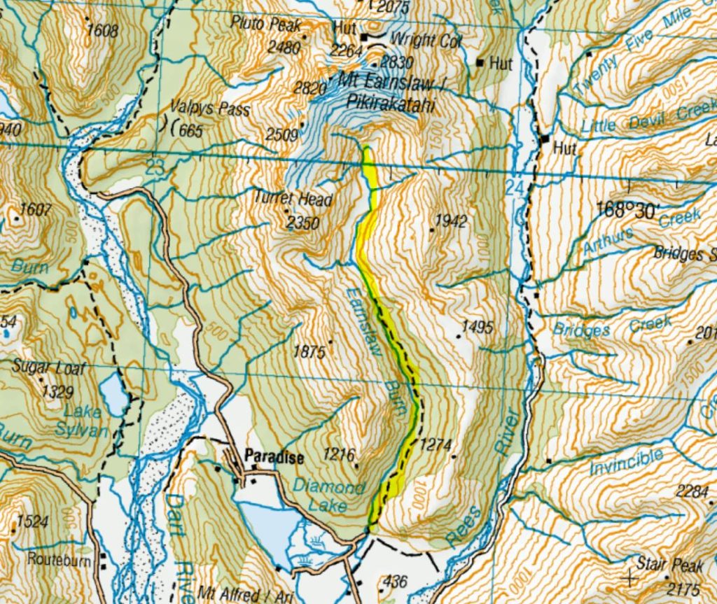
Earnslaw Burn Track
The Earnslaw Burn Track near Glenorchy is a stunning but seriously underestimated tramp – a long, technical push through the forest that opens into a sweeping valley with epic views of Mt Earnslaw. Specifically, the track sidles through conservation land above the true left of the Earnslaw Burn for about 8.5km before breaking out into a breathtaking open tussock valley on Earnslaw Station. If you’re confident you have enough time to get back out safely and are experienced, well-equipped trampers, you can press on a further 4.5km to the base of Mt Earnslaw. As you round the sweeping bend and the full face of the mountain comes into view, it’s breathtaking – but people have needed rescuing out here, so seriously consider whether you have the skills, fitness and gear before committing to this section. Allow at least 12 hours return.
Important: Experienced trampers only. DOC advises it is poorly marked, requiring navigation skills, and numerous search and rescue callouts have occurred out here. River crossing and route-finding experience is essential. There’s also windfall and slips along the track. Check the DOC website for current track conditions before you go.
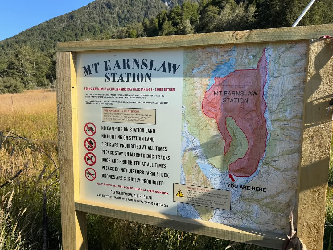
Camping update (January 2025): Camping is now prohibited on Earnslaw Station – that’s essentially everything past the bush line. You can camp on DOC conservation land at the forest edge or rock bivvy – again, check the DOC website for details. Please pack out everything you pack in, including toilet paper. The valley is under increasing pressure and it’s on all of us to keep it pristine.

Getting There
The Earnslaw Burn track starts from Lovers Leap Road, about 20 minutes from Glenorchy on the road to Paradise. Google maps will get you there, but about 4 km after the Routeburn turnoff take the right-hand fork by a silver letterbox, then cross a small stream. The parking spot is about 1.5 km further down on the left, before the big bend. There were about six vehicles in the parking area when I arrived (just outside of the school holidays on a weekday at the end of January). There are no toilets at the car park, so stop in Glenorchy on your way through.
Track and Timing Earnslaw Burn Track
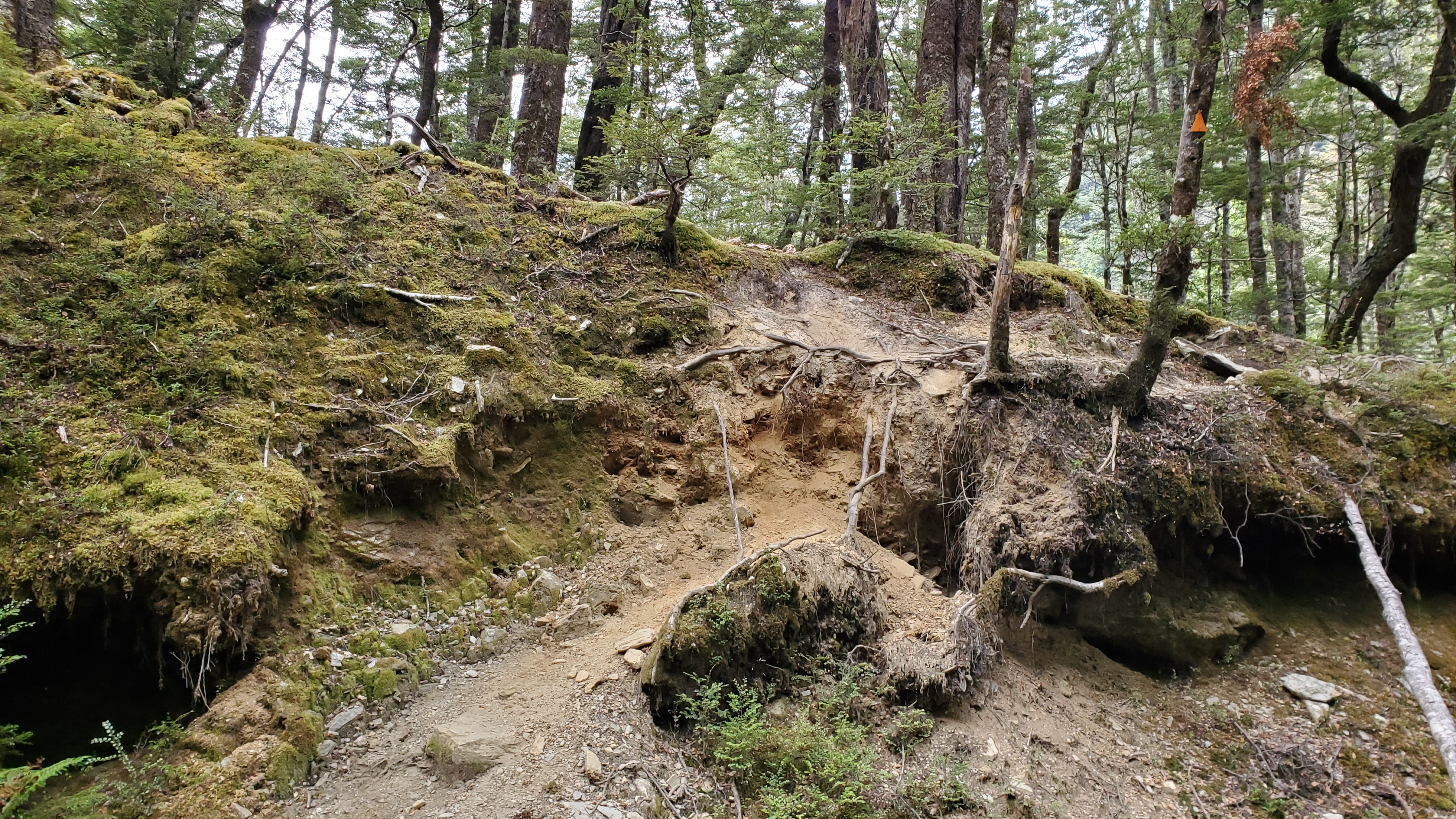
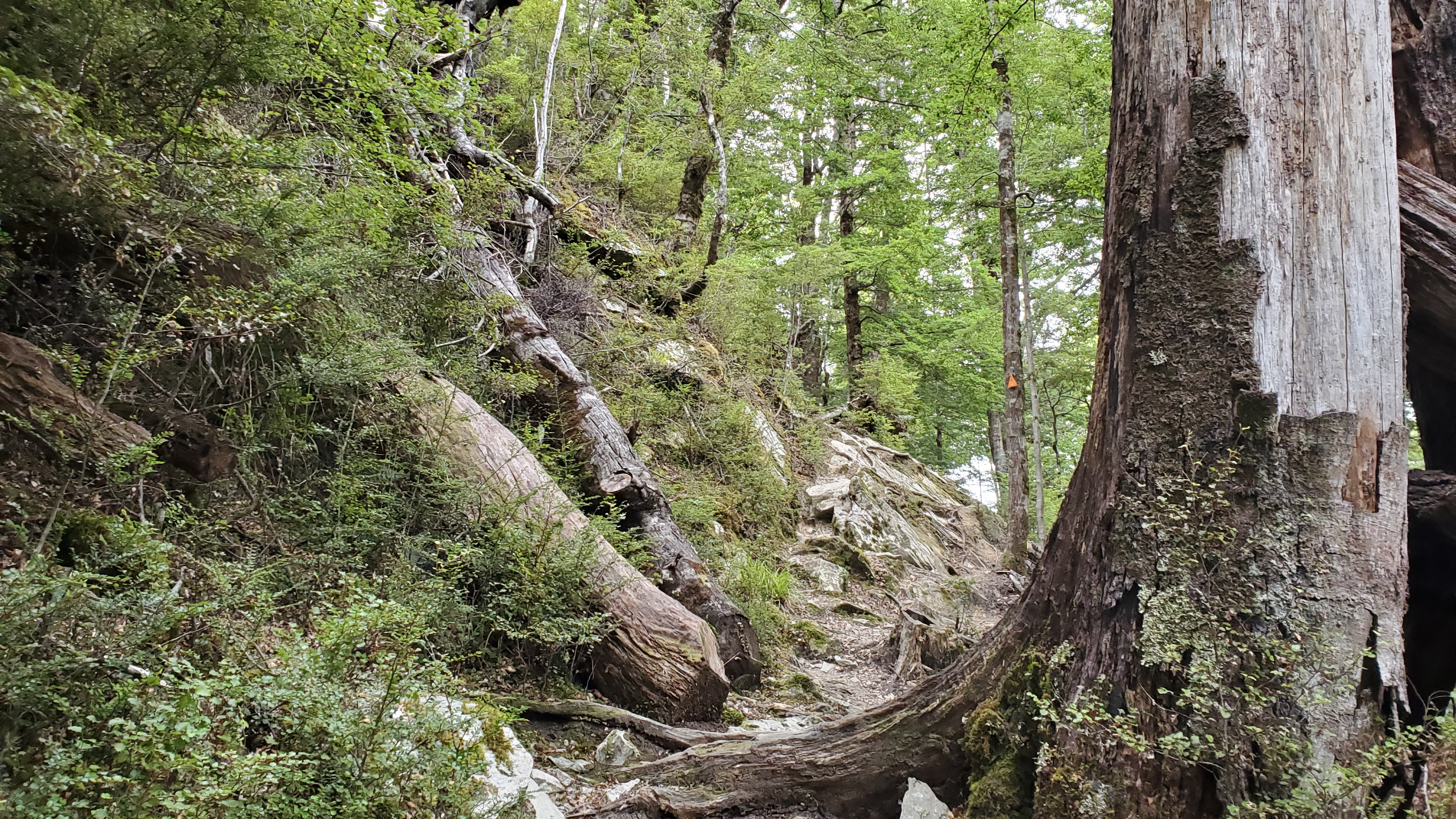
DOC classifies the track as Advanced and suggests the timing as 4-6 hours one way to the viewpoint at the bush line. Allow 2 hours one way to the base of Mt Earnslaw from here. From the DOC time, I gathered the track would be slow going. On the topo map, the it looks like a reasonably straightforward sidle and you only gain around 500m elevation overall. However, on the ground, you’re either going up, going down, picking your way up/down/over tree roots, crossing streams in gullies, climbing over logs, navigating rocks, boulders or mud, balancing, scrambling up, stepping down, sliding down, avoiding drops, clinging to branches or bits of foliage.. or all those at once.
Nearly everyone I spoke with on the track when I walked (January 2022) said the tramp took much longer than they expected. I walked the Earnslaw Burn track after spending most of the summer tramping, so my fitness was excellent. Also, I walked during dry, summer conditions. If you go when it’s wet, expect the track to take even longer than planned – the tree roots and gullies will be slippery and treacherous.

Earnslaw Burn Car Park
**EDIT January 2025 – Before heading off, check out the new signage at the start of the track.
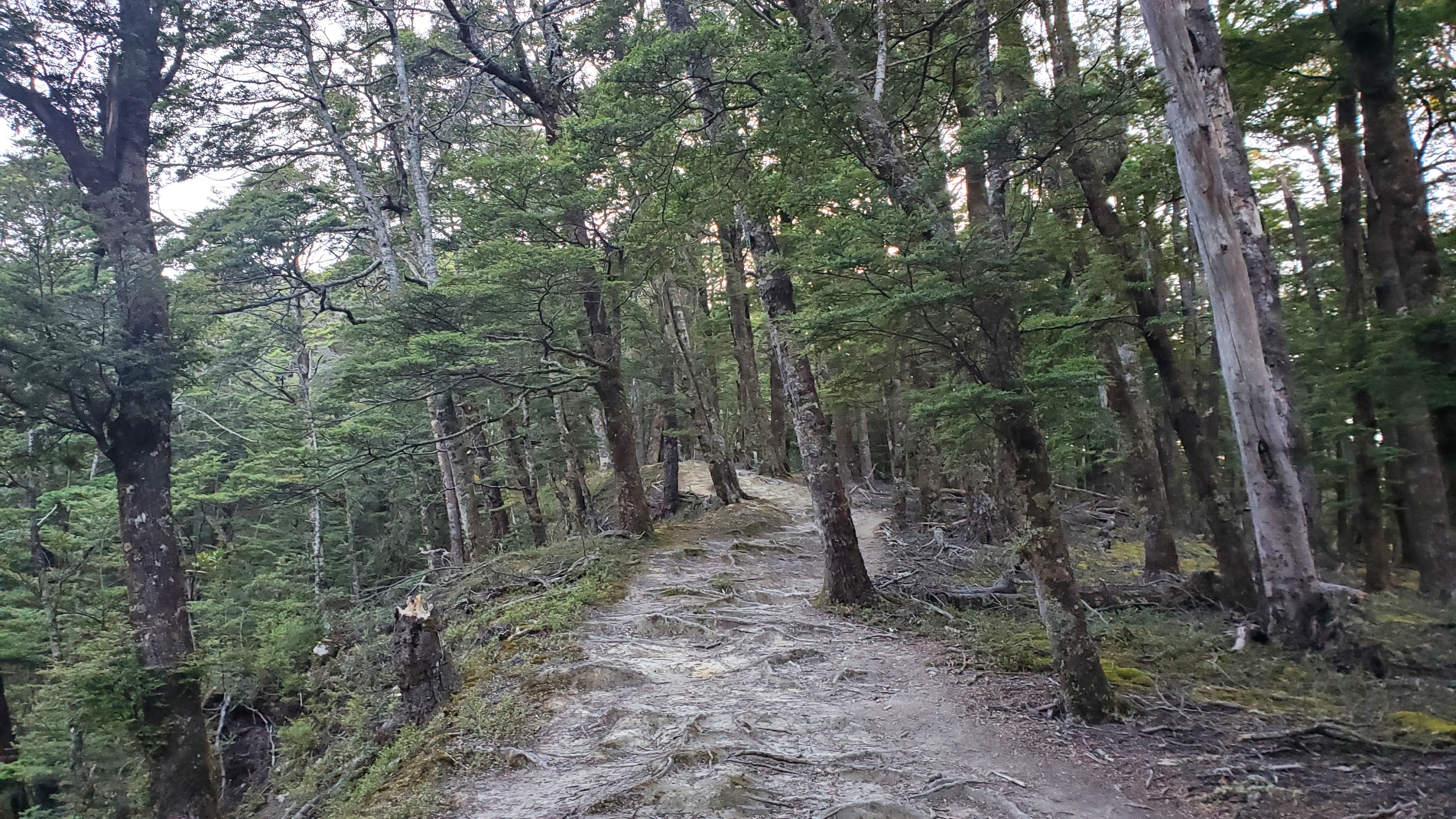
I started walking at 8 am, crossing the gate at the car park and heading across to the trees. There was a large marker and a marker in the distance. (Don’t head down to the left – towards the river). The track began with a 100m climb through the beech forest, easing into a gentler 200m climb over time. There was a short section through grass and ferns early on, so be prepared for wet feet if it’s a dewy morning.


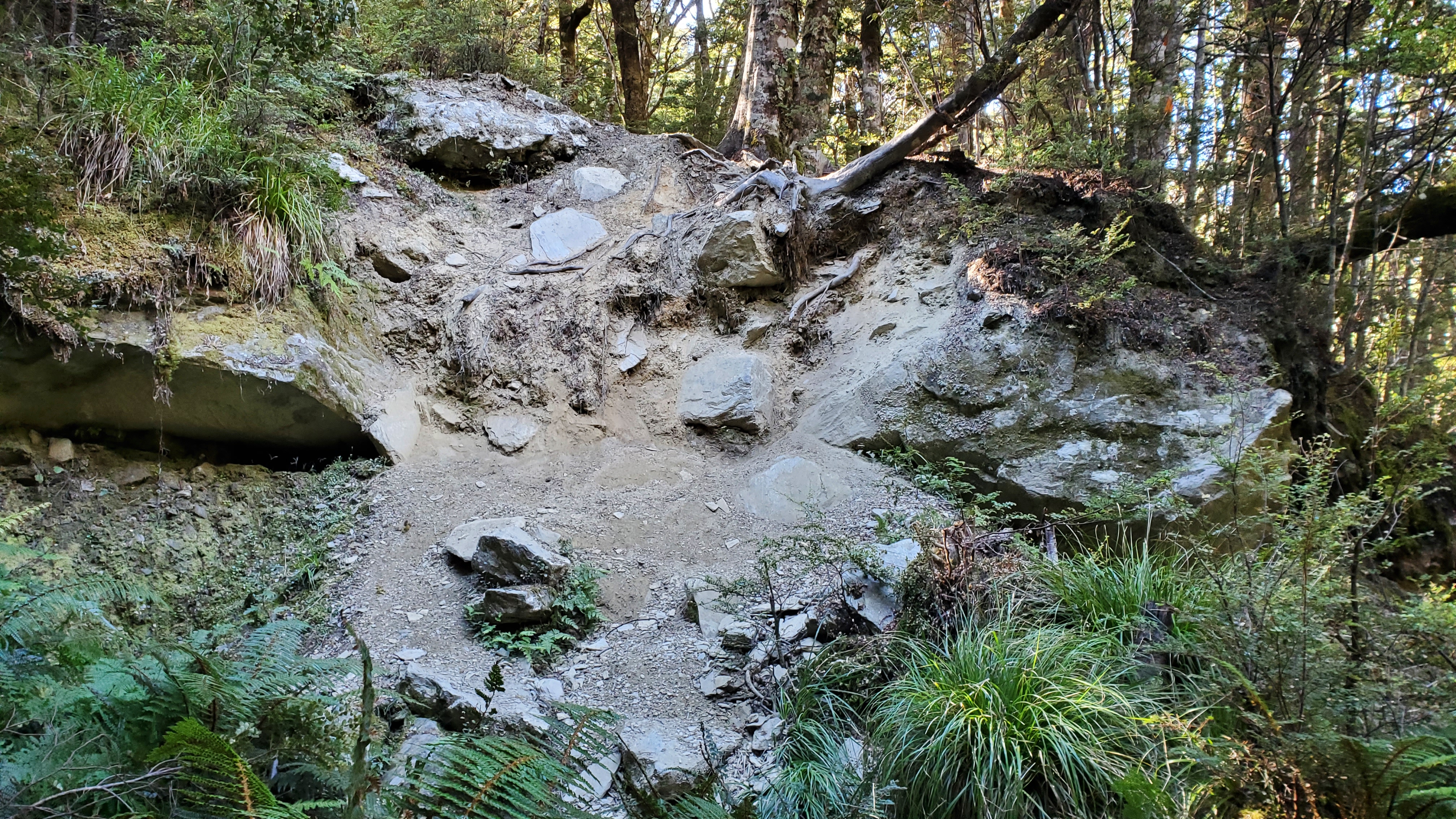
The track was well-marked and easy to follow. After the first 45 minutes or so, it became more tree-rooty and a little slower going. There was nothing too difficult in the first hour, and at 8.50 am there was a nice viewpoint looking up the valley. I arrived at the first river marked on the topo map at 9.45 am. Shortly afterwards, after a sketchy little gully, I lost the track momentarily whilst not paying attention to the markers, and had to backtrack after finding myself perched on a little ledge above a drop, with nowhere to go.

Mid Forest
The middle section of the forest was probably the most technical part of the walk, including a slip crossing that required some care. I took a quick break at 10:05 am, having covered around 4.5 km in just over two hours. The going remained slow, with a couple of awkward drops into gullies – though thankfully there were some well-worn branches to help lower myself down. Around this point, I heard the first of several helicopters heading out to the glacier.


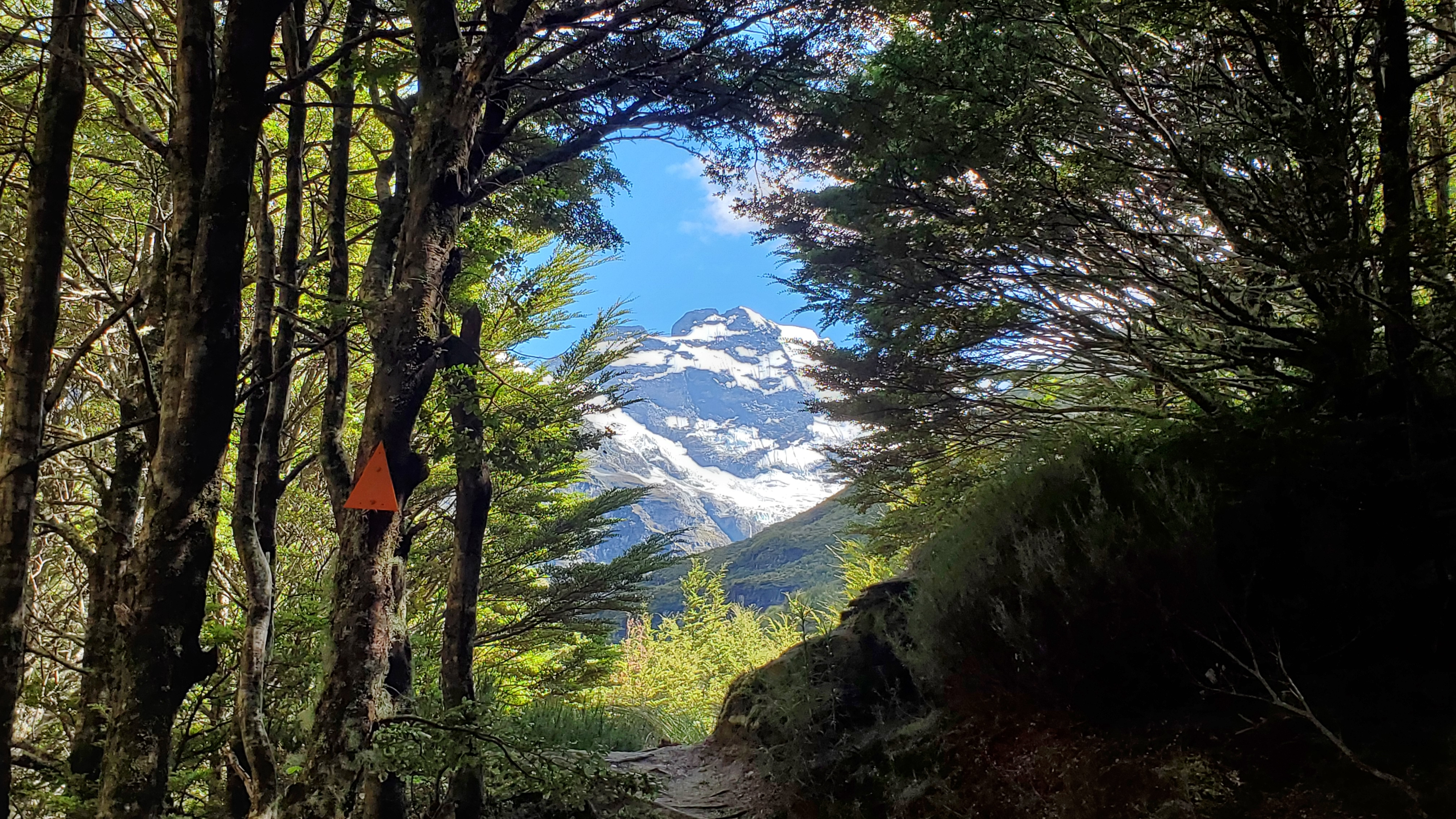
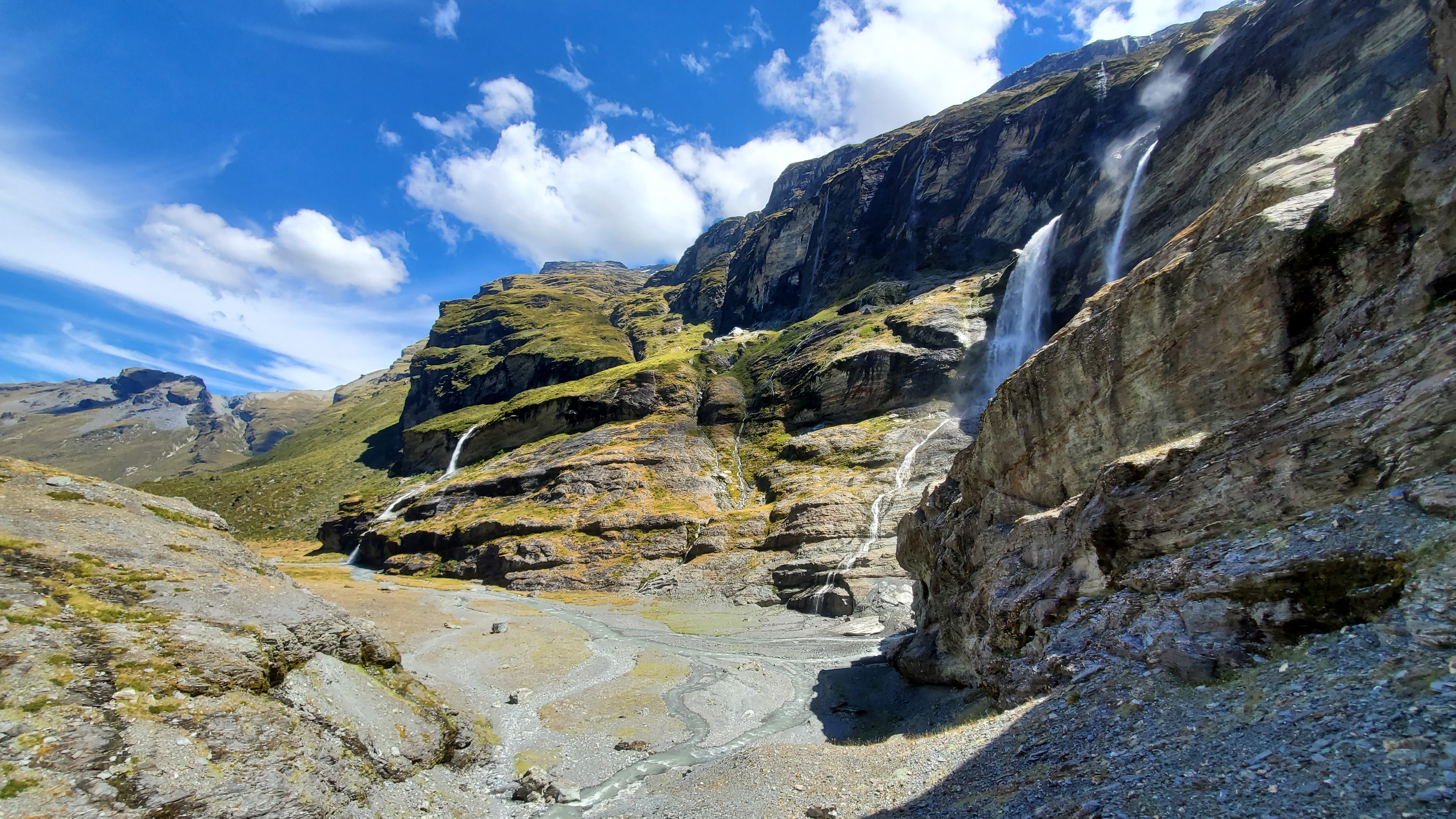
The final 30 minutes in the forest was comparatively easier. I enjoyed the occasional tantalising views of high peaks as the trees thinned. By 11.15 am, cliffs rose to the left as the valley closed in, and the first of many beautiful waterfalls appeared from them, high above. I heard a Kea call in the distance. By now, it was only half a kilometre to the bush line and only one more gnarly little climb-down before I found myself out in the open at 11.30 am.

From the Bush Line
Upon checking the map, I realised I had already passed the rock biv, which sits on the opposite side of the river. Getting to it would have required a river crossing, so I pressed on. If you’re planning to visit it, make sure you choose a safe crossing point and exercise caution (check out this Mountain Safety Council video about river crossings).
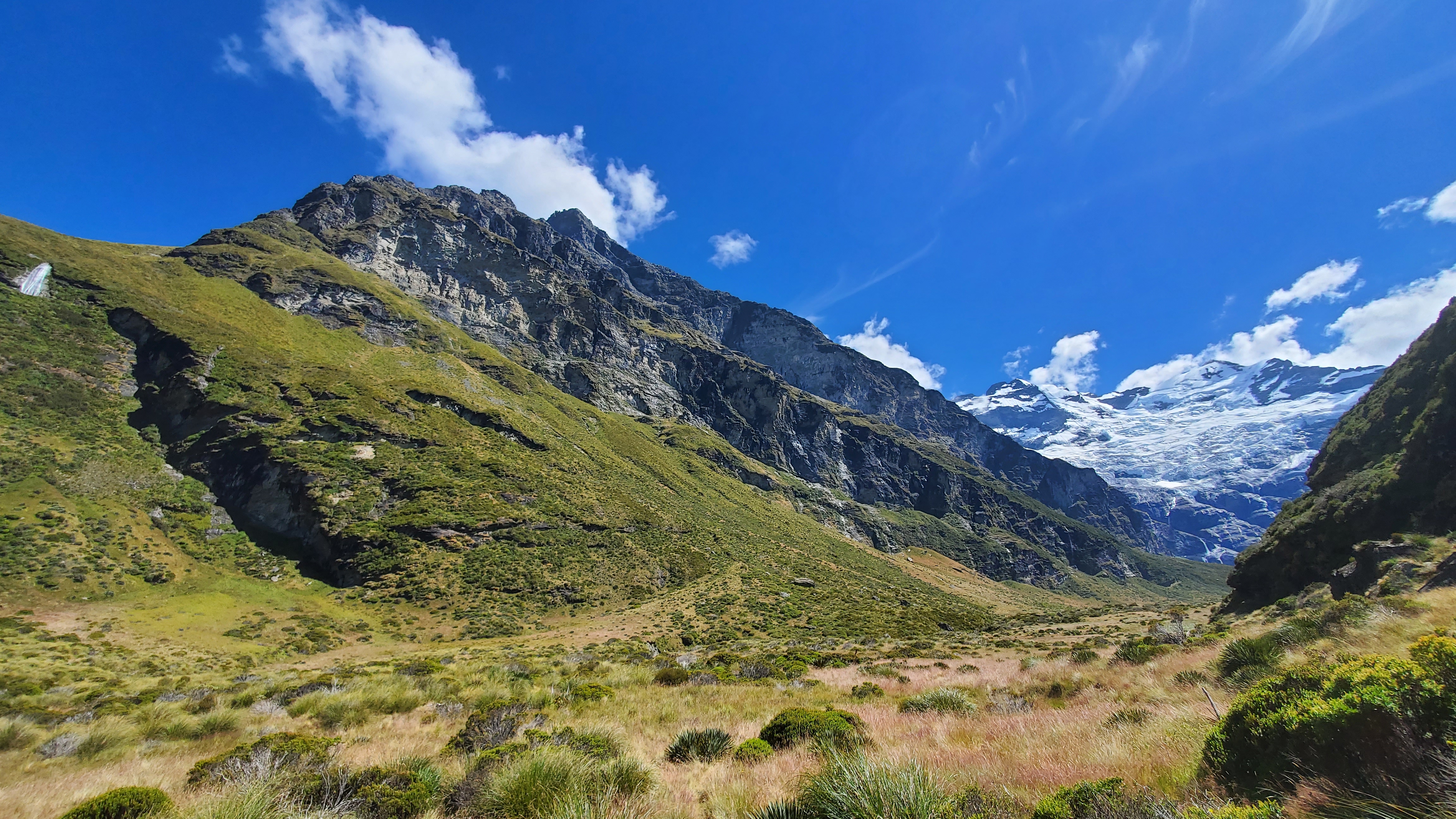
Emerging from the forest, the view that greets you at the bush line is spectacular – the imposing, slanted walls of Turret Head (2,350 m) and the distant peaks of Mt Earnslaw (2,820 m) making for quite the sight. I took one look at the tall tussocks, alpine scrub and spiky speargrass ahead and dutifully put my long gaiters on, only to take them off again within five minutes as it was simply too hot!
Beyond the bush line, the marked DOC track effectively comes to an end – from here you’re on Earnslaw Station, and the route is unformed. This section is best suited to trampers with solid experience in off-track alpine travel, good navigation skills, a sound understanding of mountain weather and terrain, and a strong level of fitness. It’s also worth noting again, that camping beyond the bush line is now prohibited.
The terrain soon asserted itself as I continued along the true left of the Earnslaw Burn, with a tricky, exposed sidle up and over a steep bank, capped off by a slick, near-vertical chute that would have serious consequences if you lost your footing.
Towards Mt Earnslaw
I continued along and finally rounded the sweeping bend Mt Earnslaw and the full glacier came into view. I had seen plenty of photos, but nothing prepares you for its magnitude! It’s breathtaking. I picked up a faint track weaving across the muddy grassy flats.

I later took a higher route through the bushes, and for the final 1.5 km, I tried not to trip over my feet as I marvelled at the glacier.

Find this helpful?
I write about my adventures to give you a personal view of the outdoors and inspire your own trips. Enjoy them? If you’d like to help me with my site costs, click here to make a donation. Thanks – it’s much appreciated!
Mt Earnslaw
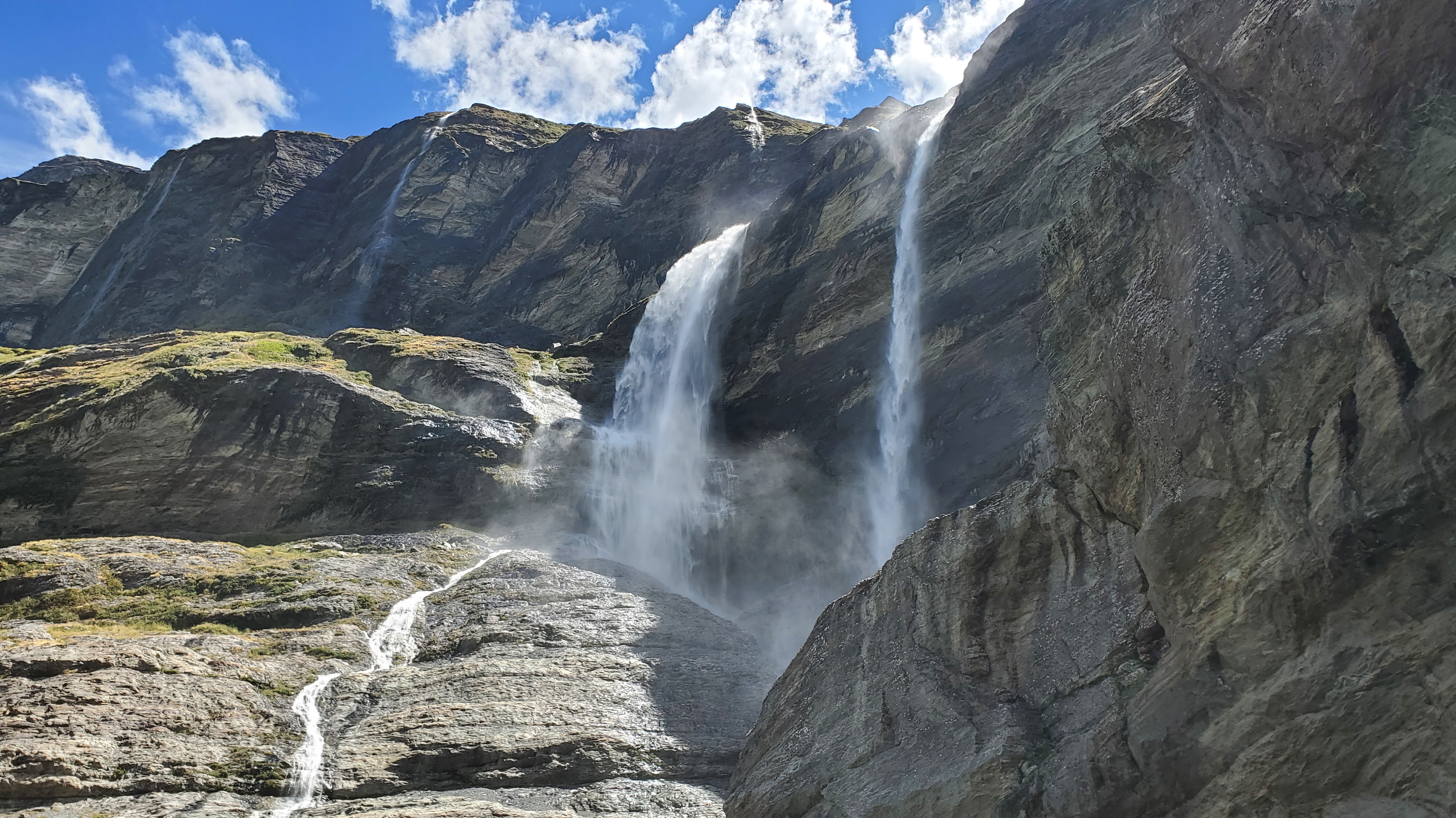
A high moraine beside the beautiful waterfall on the left provided the perfect lunch spot. I couldn’t believe I had the whole place to myself! I was mesmerized by the number of waterfalls on the face. The waterfall and river roared beside me, and even so, I could hear the cracking ice on the glacier.

Exploring
After lunch, I headed down to the flat section at the base of the wall. I dropped my pack, grabbed my plb, and crossed the Earnslaw Burn – an easy few steps through shallow water in the dry, summer conditions. I headed up a steep, slippery scree slope to the right to check out the ice patch visible from the valley. I’d seen in photos that if you time it right, with the sun on the mountain face, the ice up here shines a crystal-clear blue. But this afternoon in the shade, it was the kind of dirty brown that wouldn’t make it onto social media. Not being that great with caves, and being slightly overwhelmed with the power of the waterfalls thundering around me, I didn’t feel the need to explore any further, and just took it all in.


Heading back down, I spotted a tiny figure exploring the valley below and met him ten minutes later – a French tramper. We walked back together, and he helped me find a good spot to camp. He then very generously cracked open a beer he’d brought and shared it with me before setting off on his long journey back to the car.
On my return the following morning, the forest section took me 3 hours 15 minutes without a stop. It’s worth keeping in mind that this was under great weather conditions and I’m a fit, experienced tramper – for most people it will take considerably longer, so allow 4–6 hours from the bush line back to the car park.


Final Thoughts
The Earnslaw Burn is a serious, demanding tramp, but push through the hard work, and the payoff is breathtaking. Check the weather before you go, carry a PLB, and make sure someone knows where you’re headed and when to expect you back. There is no cell reception in the valley. And as always, leave no trace. Stay safe, and happy travels everyone, TT x
Click the links below for more walks in Otago:
- Whakaari Conservation Area, Heather Jock & McIntosh Loops – overnight
- Ben Lomond Summit (from Moke Lake), Queenstown – day walk
- Moke Lake, nr Queenstown – half-day walk
- Sugarloaf, Rockburn, Lake Sylvan – day walk
- Gillespie Pass (Young/Wilkin) Circuit – 3 days, 2 nights
- Mt Shrimpton Track, Makarora – half-day walk
- Sawyer Burn Track, Lake Hawea – half-day walk
- Isthmus Peak Track, Lake Wanaka – half-day walk
- Pisa Range – 4 days, 3 nights
- Oteake Conservation Park – 3 days 2 nights
Hi, it’s me again, Dening. I just realised you’re a woman. HOW WONDERFUL! 😀 Did you feel unsafe at any point doing these hikes solo?
Would you by any chance, fancy a day hike with me to Earnslaw Burn on 23 December? I am renting a car, driving from Wanaka to Glenorchy early morning. My family will enjoy their day in Wanaka…
Let me know. Would love tips and answers to my questions. So very grateful for your detailed write up!
x
OH WOW! I’m so very grateful for your detailed and helpful write up on Earnslaw Burn. The time you took for the various segments of the walk is most helpful. I have a few questions; would you be able to help?
First, on the topo map of Earnslaw Burn, it seems that there is only one major tributary to cross — on the true left of Earnslaw Burn, out of the forest. Is that river easily crossable? Is that where the natural bivy is? I’m still confused where the natural rock biv is supposed to be — just out of the bush line as you head towards the glacier?
Second, do you think it is safe for a solo female hiker-runner to attempt this? Safe as in, being-a-female-safe (not asking about solo hiking safe)? I’m heading on a weekday this December, will tell family of my exact plans and when I am expected to return, will have a PLB with me, etc.
Third, I intend to start my hike at about 8am, just like you. Unlike you, I do not have the luxury to camp overnight, so I will be making the way back out on the same day. I am not worried about my stamina — I run a lot, but I am worried about being able to make it before it gets dark. If I start at 8am, will I be able to get back to the car by 6pm?
Thank you SO very much!
Hi there, glad you enjoyed the blog post :). There were no major river crossings, just side streams which were all very manageable when I walked in the summer last year. I never found the natural rock biv I’m afraid, but yes looks like it’s just out of the bushline. This track is fine for a solo female, and I have never felt unsafe tramping solo in NZ as a woman. Great to hear you’ll be carrying a PLB. Have you walked/run any NZ backcountry trails before? This is quite a ‘technical’ track with lots of tree roots/obstacles, some scrambling, some steep drop offs etc. it took many people I met longer to walk it than they expected. As I don’t know what you’re familiar with tramping/running, I can’t say whether you’ll be ok with walk/running it in a day I’m afraid. I know people do day-walk it, but be prepared for a long day and take gear for all weathers, including warm and waterproof items, a head torch, and spare food/water etc. Be prepared to turn back if it takes longer than expected and you haven’t reached the glacier yet. Have a topo map on your phone/gps so you know where you are. Thanks for the offer of a trail buddy for the day, but I live at the top of the south island, not down near Glenorchy 🙂 There are lots of blogs and info out there – and if you haven’t found it already the DOC website is a great source of information for tramping in NZ. Best of luck, Jules (Tinytramper) x
Thanks for a comprehensive and informative track report.