
Gillespie Pass Circuit
If you’re looking for a fantastic multi-day tramp with beautiful dense forest, mountains galore, wide valleys, rivers and a beautiful lake, then the 58 km Gillespie Pass Circuit in Mount Aspiring National Park might be for you. It begins close to Makarora, a small settlement an hour’s drive to the North of Wanaka.
The Gillespie Pass Circuit (Young/Wilkin) is a loop track. You can start just South of Makarora up the Wilkin river, or from a few km North of Makarora up the Young River. We took the anticlockwise route up the Young River across the Gillespie Pass, and out down the Wilkin River. We completed the circuit in 2.5 days but unfortunately didn’t have enough time to take in Lake Crucible. This would probably have added in an extra overnight stop.
DOC classifies the circuit as an Advanced track and recommends 3-4 days. Click for the DOC brochure. Only experienced trampers should attempt it, with plenty of food and warm clothes and plb. Do NOT attempt the track in bad weather.
Day 1 – Gillespie Pass Circuit
Makarora and Young River to the Young Basin
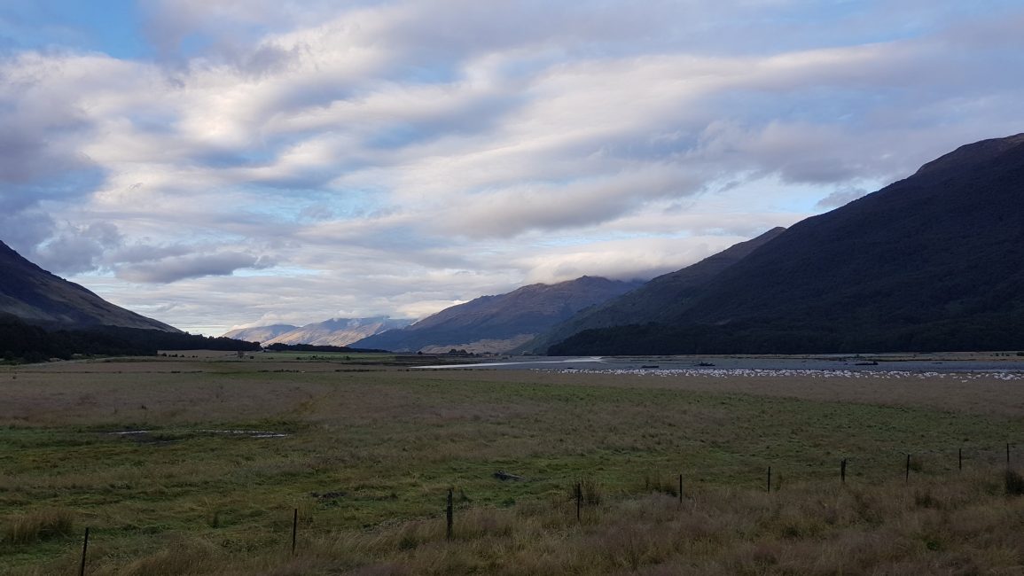
We van camped overnight in the Cameron Flats DOC campground, which has great views over the Makarora River valley towards Mount Brewster.

We left the next morning around 7 am and headed South towards Makarora village around 7 km away. We passed the Blue Pools then shortly afterward out of the forest, we saw the roadside parking area. Using the markers to guide us, we walked across the paddocks to the Makarora River.
It had rained fairly heavily the day before, and we weren’t sure if we’d be able to cross the Makarora River. We walked up the river a couple of km and gave it a go in a few places. The river was pretty swift and too deep for my liking. I didn’t want to start the day with wet undies or risk a slip into the river, so we returned to the car.
We got back to the car around 8.30 am and drove back to the parking area at the Cameron Flats campsite. From here we crossed the bridge and walked the track to the start of the popular Blue Pools walk. The Blue Pools were nice enough, but we were a tad underwhelmed. (As a side note I drove past the Blue Pools a few days later to pick up the van and it was PACKED!! If you are intending to go there, go early!)

Blue Pools Track Gillespie Pass Circuit
The Blue Pools track added around 5 km (and about an hour and a half with the drive back etc.) to our day. We got back down to our original/intended crossing point of the Makarora River at 10.45 am. This was by the jet-boat drop-off point. Note that you can get a jet boat across the river from the village by pre-arrangement with Wilkin River Jets, but we preferred not to, plus they required a 3-person minimum payment.

So we passed the jet boat drop-off point and immediately there was a very steep bluff to negotiate with chains provided to help you up the rock. As we climbed we saw two other couples on the other side of the Makarora river looking to cross and wondered if they’d risk it.

Young River
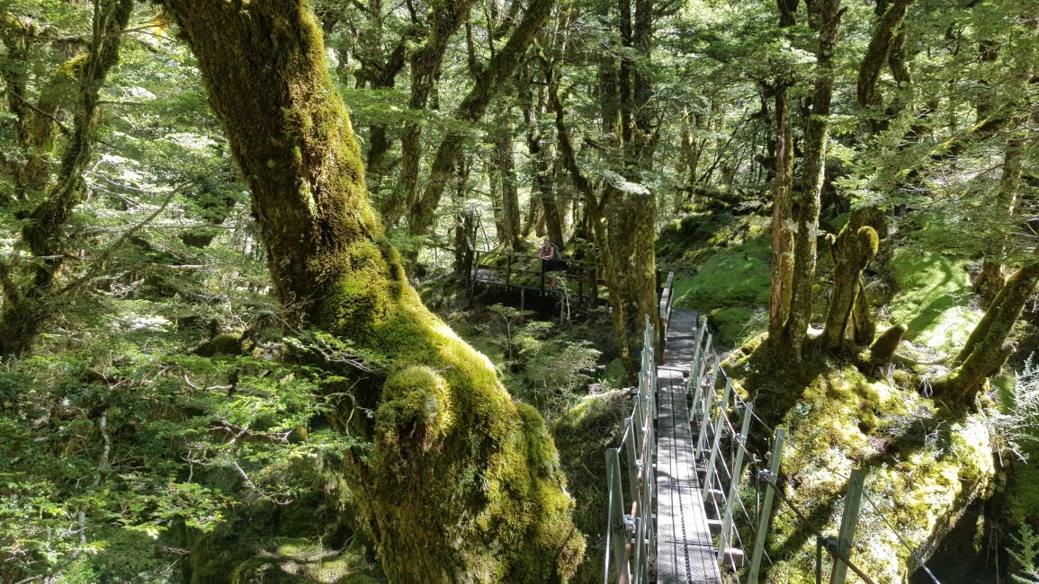
After climbing the bluff we came back down and found ourselves at the confluence of the Young River. The trail headed up the true left of the Young River towards Young Hut. It was a lovely track, tree rooty but nothing too gnarly. There were some small ups and downs through the mossy forest and a few overgrown, wet, slippery sections across some areas of former slips.
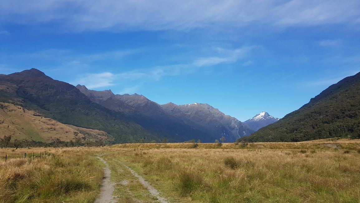
As we continued on, the trail came out into the flat grasslands of the valley, where the trail was well-marked and easy to follow. We enjoyed our lunch in the sunshine.
We continued through the forest and grasslands until we came to a final climb of a couple of hundred metres. At 4 pm we arrived at the 20-bed Young hut. To be honest I wasn’t that fussed about the hut. Firstly there was no camping. I’m a really light sleeper, so I would rather camp outside a hut than sleep in one. Secondly knowing we had a big day tomorrow over Gillespie Pass, we thought it might be an idea to get a head start on ourselves while it was still early and get some of the climb out of the way. We decided to push on and climb another 200m up to the open flat valley of the Young Basin.
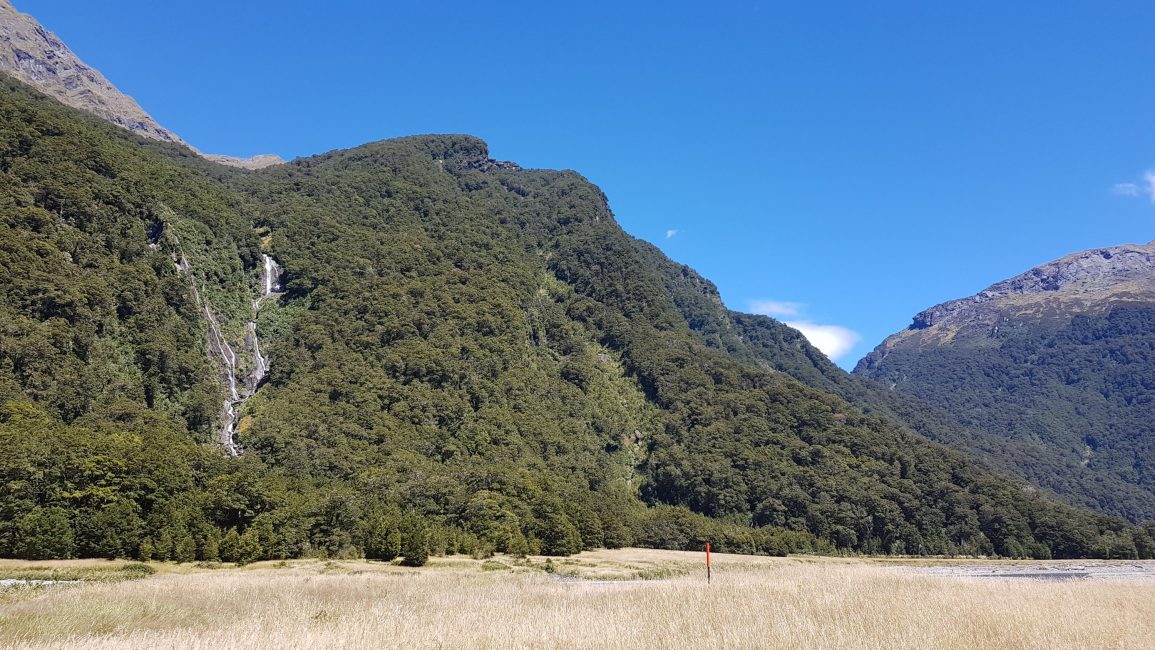
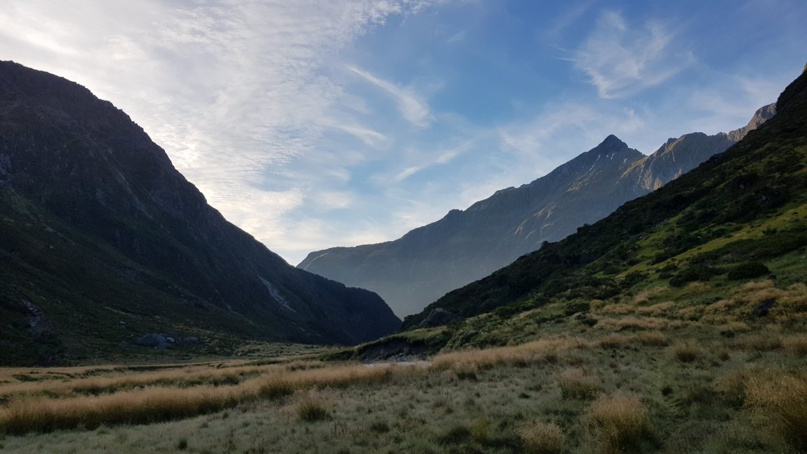
The Young Valley
The Young Valley is worth a visit even if you don’t make it over Gillespie Pass. It was a spectacular sight, as the mountains formed a huge cirque in front of us. The beautiful alpine vegetation here was quite different from that which I had seen before. (It pains me to say that unfortunately, I don’t know the names of any of the flora up here. I always make a note to self that I really should tramp with someone who knows all the trees and plants, or at least take the time to do my own research).

We made camp on a flat section just beyond the bridge, with epic views. It was possibly the best wild camp I’ve ever had. It goes without saying that whenever camping out like this, you strictly leave no trace.

We set up the tent and I went for a swim in the river. Given that the water from the river was coming directly from the snow-capped mountaintops around us, you can imagine how cold it was. Note that in bad weather this valley becomes treacherous and floods – people have lost their lives. Do not come up here or attempt to make the crossing in bad weather.
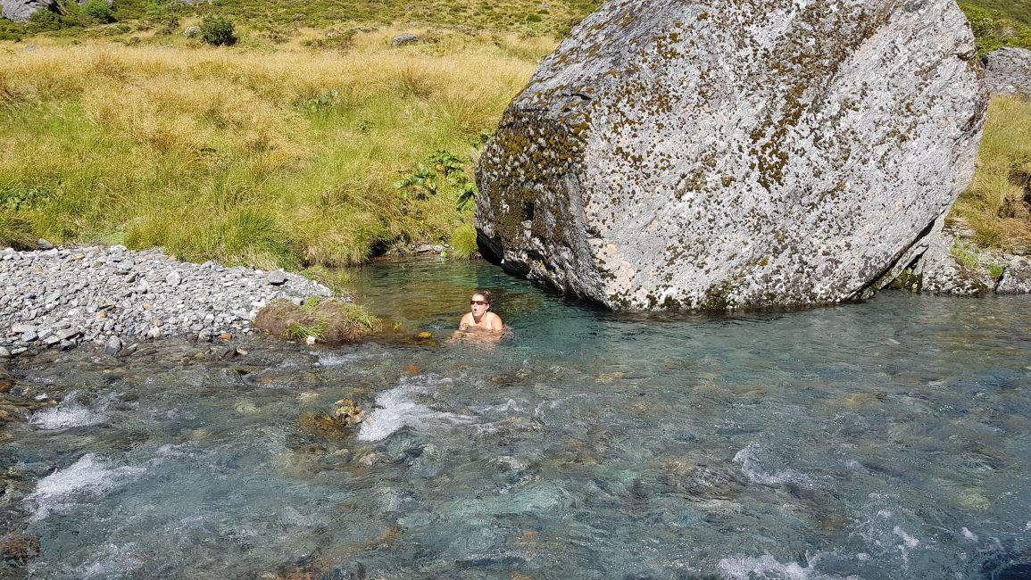
We sunbathed, made dinner and marveled at the views, and spotted some chamois on the mountainside. Numerous waterfalls were spilling down the mountains around us. It was a glorious evening. We noticed then, that there had been no sandflies to blight our evening. The only explanation we could think of was that we were too high for them, at an elevation of around 900m.
We went to bed at 8.30 am and waited for it to get dark.
Day 2 – Gillespie Pass Circuit
Gillespie Pass, Siberia Valley, Wilkin River to Dans flats
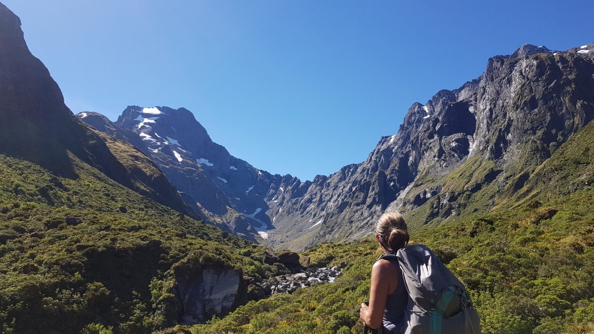
We were really excited to get over Gillespie Pass!! The following morning we left at 7 am and immediately got stuck into a 600m or so steep climb up the mountain track. Much of it was a well-marked, slippery trench.
It was pretty steep and slippery underfoot. There was some scrambling involved but nothing too difficult or scary for experienced trampers. I was pleased not to be coming back coming down this way.
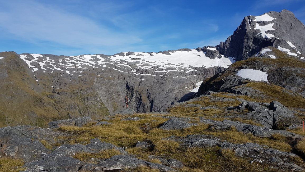
We were on top of Gillespie Pass by 8.30 am. It was incredible. There were amazing panoramic views of the Young Basin and Gillespie Basin, and of Mt Awful and numerous other peaks – some over 2000m in elevation.

The sun shone, and there was no wind at all. One of the benefits of not staying at the hut, and getting up early is that we had the place all to ourselves. It is moments like this that make the days’ worth of sometimes difficult walks in, up out of places like this, completely worthwhile.
Of course, we are always prepared for the worst. Even if glorious weather days like this are predicted I’m always carrying my warm layers, waterproofs and my PLB (personal locator beacon). You certainly wouldn’t want to be coming over here in bad weather.

We took the obligatory photos, stared open-mouthed in wonder, and slowly made our way over the pass. There were still patches of ice on the pass so we had to take care with the crossing.
The route down wasn’t as bad as the up, but wow it was long! I was glad again that we had done the circuit in the anti-clockwise direction.

A short way down we had a break and took in the views on the Gillespie Stream side of the pass. The track descended into nasty little hillocks of clumps of wet, slippery snowgrass, with boggy sections in between, but aside from that small part, it was otherwise a pretty decent path.
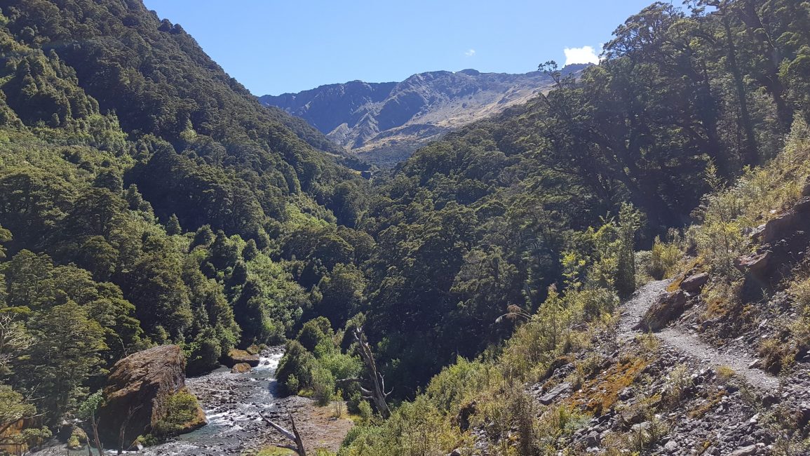
We got down beneath the treeline and into the bush. We descended further for a couple of km through a lovely forest track around and down into the Siberia Valley.

Siberia Valley Gillespie Pass Circuit
From here we enjoyed a stunning walk along the flat grasslands of the wide Siberia valley. The trail runs along the Siberia stream, which was running clear and blue. We saw the turning for Lake Crucible and paused for a moment to think about whether we could squeeze it into our itinerary, but decided that sadly, we couldn’t on this occasion.
We hadn’t done a lot of research for this trip. Also, because I’m reasonably new to hiking/tramping I hadn’t heard of Siberia Valley and Lake Crucible before. Since my return I have spoken to heaps of people who say that Lake Crucible is a must-do, so be sure to make time for it.

In the far distance, we could see Siberia hut, and as we got closer a small, yellow plane flew over us, then landed on a tiny grass airstrip just over the river.

We reached the hut at 12.30 pm for lunch. The view from the hut back into the valley is possibly one of the best hut views of our summer so far!

Siberia Hut
The Siberia hut was spotless, the toilets clean and fresh, and the warden had cut the grass. We dried out the tent and our wet shoes and socks.

We left at 1.50 pm. From Siberia Hut the track was amazing! It was without a doubt ‘great walk’ standard. We learned from the hut warden that farmers used to drive their cattle up here to the grasslands of the Siberia Valley many years ago. These days it’s part of the ‘Siberia Experience‘ where people pay a decent amount of money to fly in, hike the perfect 7km track down to the next hut at Kerin Forks, then get a jet boat back out to Makarora. I’m considering it for next time when I do the walk up to Lake Crucible.

There were wonderful river, mountain and waterfall views along the 7 km of Siberia track.

Kerin Forks
We reached Kerin Forks at 3.30 pm and had a quick break. The jet boat goes from here back to Makarora village, and we heard one roaring up the Wilkin River long before we could see it. From here the track turned back into a regular tramping track. It followed the Wilkin River on and became tree rooty with lots of little ups and downs – quite the difference to the perfect track from Siberia.
We came in and out of forest and valley grasslands. I didn’t enjoy the grassland section as I got horrific hay fever and sneezed my way over Kerin Forks flat and into Dans Flat. Dans Flat was quite high above the river, and we trudged on, not finding anywhere decent to camp.
Finally, we dropped down to river level at the end of the flats and decided to pitch near a small stream on the rocky floodplain. It wasn’t ideal but we were over it for today. We set up the tent around 5.45 pm, had a quick wash in a tiny stream, and made dinner. Sleep came easily and before dark.
Day 3 -Gillespie Pass Circuit
Wilkin River – Dans flats to Makarora
We woke at 6 am to the sight and sound of hundreds of sandflies in between the inner & outer tent fly. This didn’t bode well. There were far too many sandflies to have coffee and eat breakfast, so we got going immediately after Blair hurriedly packed down the tent. I grumbled and moaned a lot.

I had a bad start to the day and I was really tired after yesterday’s exertions. The trail down towards Makarora wasn’t particularly enjoyable (uppy, downy and tree-rooty) and I missed having my breakfast and leisurely get-up. Hurrumph. Blair wisely walked ahead and kept quiet after I shot down all his efforts at making things better “at least it’s not raining Jules”. Afterward, I felt terrible for being so miserable.
What seemed like an age later, but was probably only 4 km, we were out of the forest and onto the huge flood plain and the confluence of the Wilkin and Makarora rivers.
Makarora River
I cheered up as we came out into the open. It was flat and sunny, and my hay fever hadn’t kicked in yet. The trail officially ended here, so we made our way down to and across the Makarora River. We found a four-wheel-drive track and followed it for another couple of kilometres as it headed left following a line around the base of the mountain. Looking back up the valley, we got some great views.
We headed out from the mountain towards the Makarora River. The valley here was very wide and the river braided, clear, shallow and not too swift. That ‘shallow’ looking river came up almost to the bottom of my pack as we crossed, so it was wet shorts and undies for the final walk out.
Once over the river, we’d intended to somehow get out to a little side road and then walk on the main road the few kilometres into the village. But there was a nice track (not marked on the map) right beside the Makarora River. A fisherman told us it went all the way into the village – yay!! It didn’t take long to get back, and we arrived in Makarora village at 10.45 am. Time for an ice cream from the cafe, followed by coffee and a pie.
The van was 10km away at the Cameron Flats campsite car park, so we took turns to hitch (to collect the car and drive it back). I got the hitch within 10 minutes and was back quickly with the van.
I’ll be back to the Makarora area to check out the many other hiking options. For the Lake Crucible walk, I will go luxury and use the plane-hike-jetboat option 🙂
Click the links below for more walks in Otago:
- Mt Shrimpton Track, Makarora – half-day walk
- Sawyer Burn Track, Lake Hawea – half-day walk
- Isthmus Peak Track, Lake Wanaka – half-day walk
- Ben Lomond Summit (from Moke Lake), Queenstown – day walk
- Moke Lake, nr Queenstown – half-day walk
- Whakaari Conservation Area, Heather Jock & McIntosh Loops – overnight
- Sugarloaf, Rockburn, Lake Sylvan – day walk
- Earnslaw Burn – overnight
- Pisa Range – 4 days, 3 nights
- Oteake Conservation Park – 3 days 2 nights