
Waipakihi River – Kaimanawa Forest Park
Today’s hike was one of those where we left a bit to chance. The aim was to head to the Waipakihi hut from Mount Urchin, but we were being a little spontaneous about it. To be honest I hadn’t read up on it much and the weather wasn’t being particularly kind either. At some point in the past, I had downloaded a gpx file of the routes to Waipakihi hut onto my Backcountry Navigator (topo map app) on my phone, so this acted as our guide.
We van camped overnight in the marvelous DOC campsite beneath Mount Urchin. It was packed with around 15 vans and cars. We were hiking the Waipakihi after a pretty grueling 3 days on the Round the Mountain (Ruapehu) track, so we allowed ourselves a lie-in, and a magnificent breakfast.

Mount Urchin
We left Urchin campsite at 10 am, and road walked 20 minutes uphill to the trailhead. We reached the Urchin trig at midday after the steady climb. For more details about the Urchin track see my recent post. It’s an amazing, accessible short hike, and rewards you with incredible views of Mount Ruapehu, Ngauruhoe and Tongariro as well as sweeping views of Lake Taupo and the Kaimanawa ranges.

We stopped for the obligatory photos at the trig and decided on our next move. This week we’d seen gale force winds on Ruapehu, and it was the same on Mount Urchin. A quick check on the weather earlier had told us that the winds were due to subside tomorrow, so we decided to go down to the Waipakihi river and walk to the hut and return on the exposed ridge of the Umukarikari track.

We walked across the tops from Urchin trig for about 30 minutes until the track divided, then began the very steep descent down to the Waipakihi river.
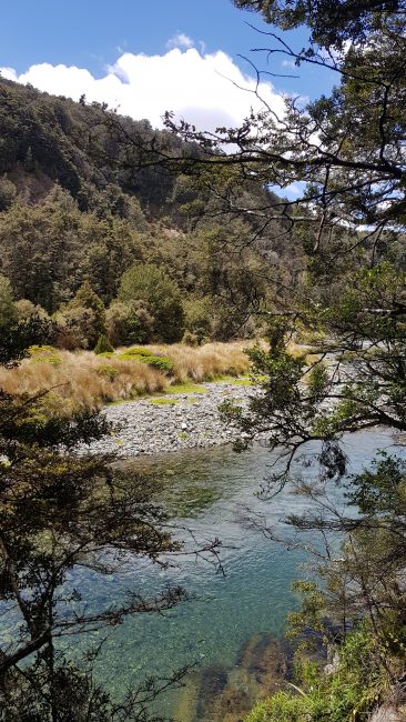
Waipakihi River
We reached the river at 1.30 pm and ate our lunch. There was a DOC signpost that notified us that the Waipakihi hut was 4-5 hours upstream. As we were usually a lot quicker than the standard recommendations, we assumed we’d be there by around 6.30 pm.

Unfortunately, I made the mistake of treating the gpx file on my topo map as gospel (I couldn’t remember where I’d downloaded it from) and we spent ages searching for a seemingly non-existent path/trail on the true left side of the river. We ended up with a bit of winging it, and a lot of checking the route on the app and confusing ourselves even more. We bush bashed, trudged through bog, went up over and down various riverbanks, and scratched our heads at exactly why the route on the map had us taking this line. I guess this is why I usually do more planning,
River Crossings
Most of the river crossings were easy enough, especially given all the rain we’d had recently. However, Blair and I hadn’t had the conversation about my comfort level re. river crossings and what I was happy to cope with (or not). This lack of communication ended up with me having a huffy moment as I struggled up to my thighs through one particularly deep bit of river whilst he (completely unaware of my ‘situation’) carried on ahead. I blamed him for not looking out for me – whilst he was completely unaware that I was struggling behind him. A good learning experience – we should have talked about each crossing beforehand and crossed as a pair if I was in any doubt like I did with the guys on Te Araroa trail. We named that part of the river ‘Pissy Corner’ and had a laugh about it later.

Needless to say, the day was really slow going and we became annoyed with ourselves and our slow progress. In hindsight, I have no idea why we didn’t just make our own way up the river. We had done this so many times on Te Araroa trail – walking from bank to bank to find our own route.
Making Camp
By 3.30 pm we’d only covered about 4 km up river to the hut. We decided to turn back and camp at one of the lovely spots we’d seen right at the start, at the bottom of the steep descent. At 5 pm we picked a sunny camp spot on the true left bank around 300m upstream from the crossing point.

We set up Blair’s new tent – a Big Agnes Fly Creek UL2. It’s a roomy one-person and snug two-person tent. There was ample room for ourselves and a few belongings inside, and our packs and shoes in the vestibule. We spent the evening enjoying the sun, and swatting hundreds of sandflies.

Back to the Tops
We woke the next morning to glorious sunshine and light winds. It was a pleasure to enjoy a leisurely morning. Usually, we’re up and out pretty quickly. Today we waited for the tent to dry out, and didn’t leave camp until 9.35 am. The 400m climb back out wasn’t nearly as daunting as I had expected, and we tackled it enthusiastically. We were up on the tops and an hour later basking in the sunshine.

On our way back, we looked over towards the ridge and the Umukarikari track and put it on the list for another time. Not the greatest trip in terms of planning and execution, but some great views and good lessons learned.