
The Lockett Range and Mt Cobb Tops
We made the most of great weather over the New Year and headed into the Cobb to traverse the Lockett Range and Mt Cobb tops of the Peel Range over three days, and two nights. As usual, the Kahurangi National Park didn’t disappoint, and we enjoyed a superb few days exploring the glaciated landscape. It was one of those trips that makes you realise how many other possibilities there are up there and makes you want to go back again and again.
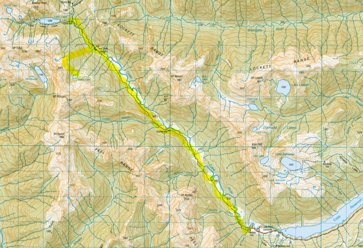
We began with a traverse of the Lockett range tops starting from the Sylvester Hut Track via Mt Iron and Mt Benson. Our first camp was approx 1 km before the Waingaro Peak Track above Fenella hut. The unmarked route took us a leisurely 10.5 hours. The following day we went down into the Cobb Valley and up the other side via the Cobb Lake Track. From there we headed up to Round Lake, then headed back around Cobb Lake just beneath Mt Cobb to Camp Lake. On day 3 we made our way down from Camp Lake and walked the Cobb River Track along the valley floor back to Trilobite hut – an easy and very beautiful 13 km.

Getting there
Getting up and over to the Cobb Reservoir is easy if you’re driving a suitable vehicle. The last time I went to the Cobb, to walk up Mt Peel, I was driving my ageing camper van.
The 2-hour drive from Takaka was infinitely more pleasant in a 4WD vehicle this time. To get into the Cobb Valley take the Cobb Valley Road from Upper Takaka off the SH60 on the Takaka side of the hill. Follow it all the way and it becomes the Cobb Dam Road. It becomes unsealed halfway along. Continue up to the viewpoint on the top (which has a decent long drop) and head down to the reservoir.
We were starting and finishing from different points in the Cobb Valley, so we dropped a bike off near Trilobite hut at the far end of the reservoir and left the car at the start of the Sylvester Hut Track. This meant that one of us could bike back 30 minutes to get the car at the end of the trip. Luckily the matter was taken out of my hands when the boy gallantly volunteered to do this, and I happily accepted.

Day 1 – The Sylvester Lakes Track to (almost) Waingaro Peak Track
Having woken at 4 am we started walking at 7.25 am. After a short faff, involving Rich running back to the car to look for my missing long gaiters which I had forgotten to pack (sigh…) we got going.

The Sylvester Track is an easy walk up through beech forest along a four-wheel drive track. I was nursing a gentle hangover (which was more lack of sleep than a hangover) but managed the 5 km and apr. 500m ascent to Sylvester hut with plenty of complaining in a respectable 1hr 20 mins.
It had been a busy New Year’s Eve at the 12-bed Sylvester hut, and plenty of people were enjoying the fresh air with their breakfast as we arrived.

Sylvester Lakes
We continued on to the Sylvester Lakes. It was overcast, the temperature was perfect, the track flattened out and I was now nicely warmed up. Just as I was starting to enjoy myself, the first song to pop into my head for 2020 was Bruno Mars ‘That’s What I like”… crikey.
The Sylvester Lakes were lovely. The marked track ended and we walked through the tussock between Big and Little Sylvester Lakes and around the southeastern side of Iron Lake towards Iron Hill.

We crossed the Iron Lake outlet 1460m then headed up Iron Hill. It had looked like a fairly gnarly ascent from afar, but now that we were on top of it, it wasn’t so bad at all. We tackled it in next to no time, following the cairns to the summit at 1695m.
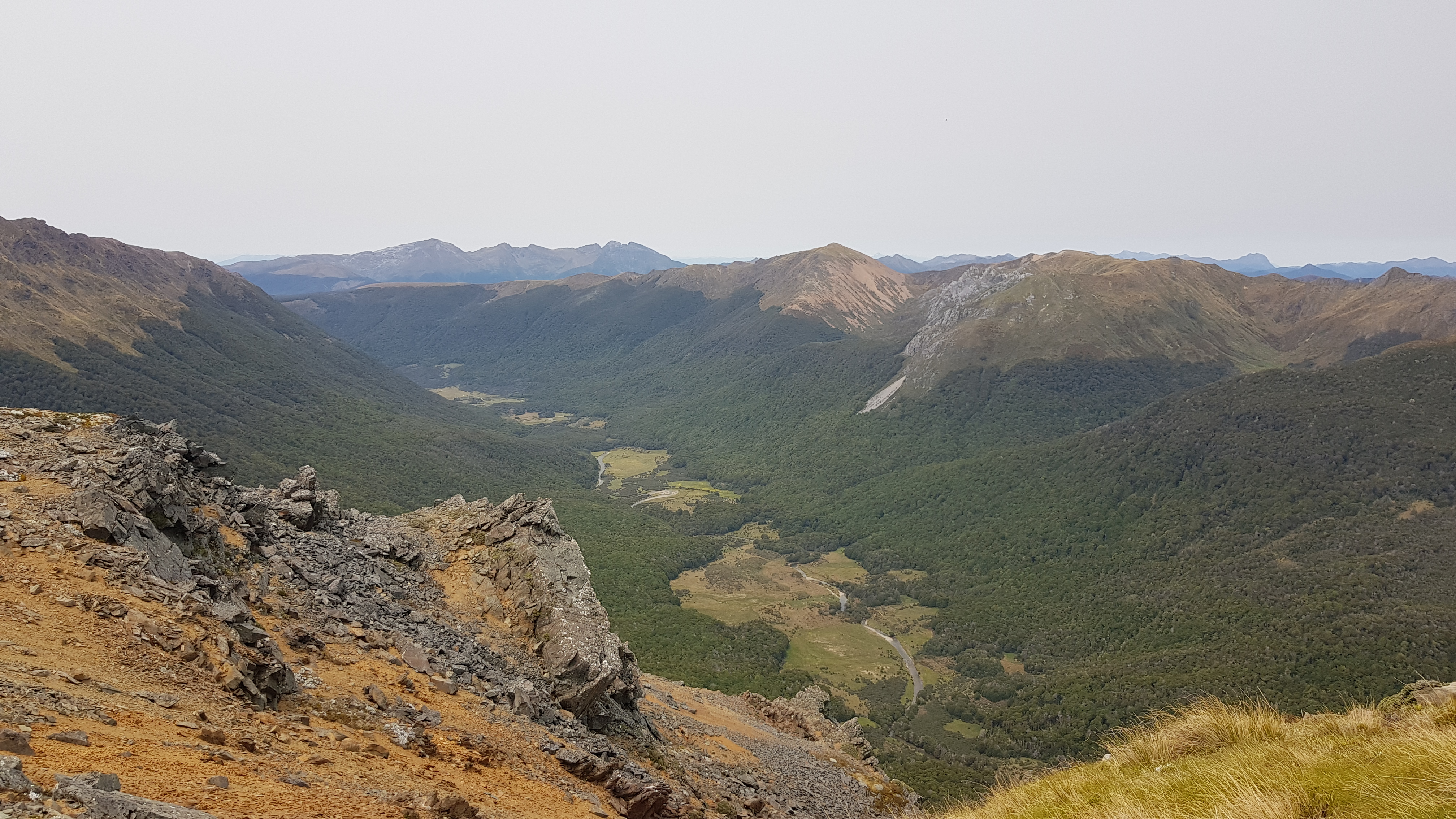
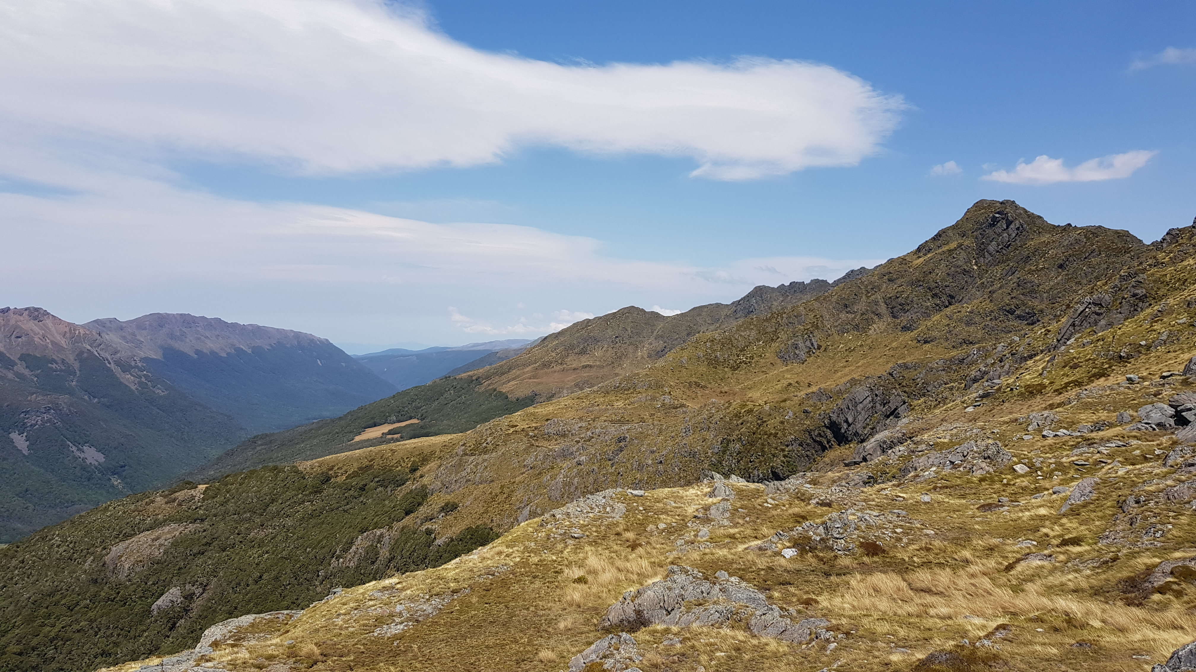
The views from the top were outstanding and set the scene for the next three days. We could see across the Lockett Range and Peel Ranges on either side of the Cobb Valley. The seemingly limitless Kahurangi National Park stretched far beyond.

Traversing the Lockett Range
What can I say about the rest of the day? It was brilliant. We followed the ridgeline, making our own way and spotting the odd cairn here and there. We were buffeted quite heavily by the strong wind, we scrambled up over and down rock, tussock, grassy slopes and scree. I randomly summoned some Kea (alpine parrots) and strangely a pair came!! We saw skink, and to my delight saw big flocks of vegetable sheep.


Mt Benson
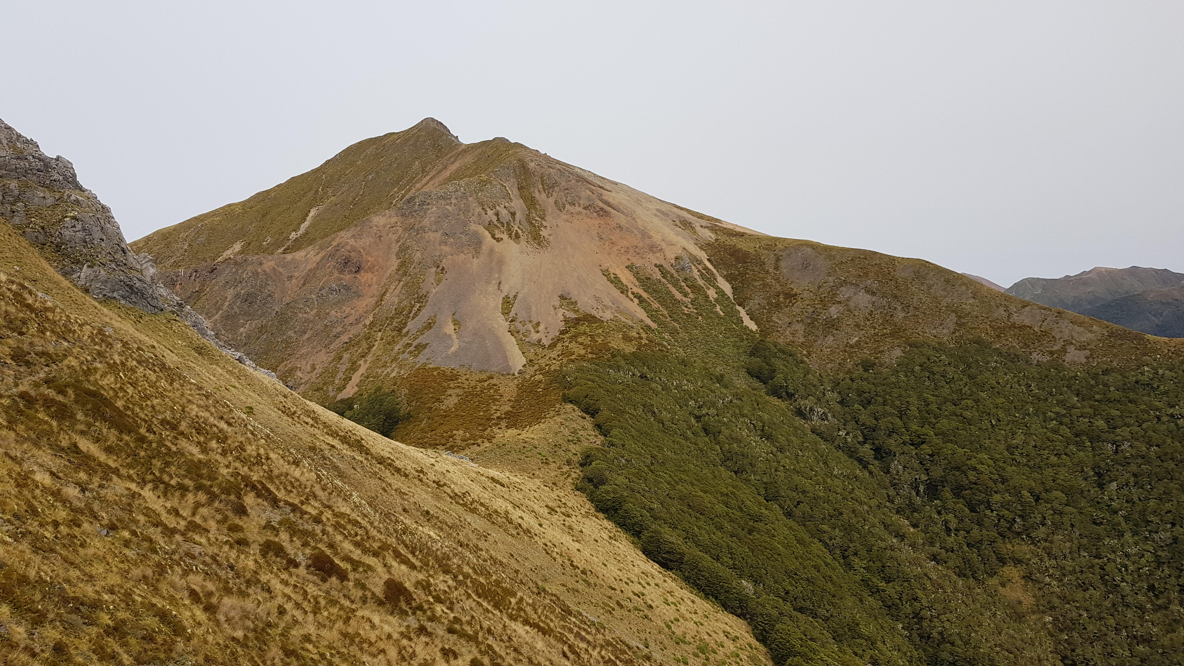
We found a sheltered spot behind a rocky bluff and ate our lunch at 1 pm. Mt Benson 1661m and its sister peak at 1672m loomed ahead and we knew we’d be in for a climb or a scree sidle. We opted for the sidle, as Rich had been over the top before and knew I would hate it.
We went for a route across the steep Western flank. As it turned out, I wasn’t really up for the 1.5 km sidle either. Some of it wasn’t too bad and we rock-hopped across the bigger debris. Further along, the scree became loose – the kind where your footsteps create mini avalanches about your feet. There was a significant amount of overhanging rock and scree above us. I hurried along, quietly swearing and complaining as each footstep dislodged the fragile balance of the slope. No doubt I was being a bit of a drama queen about it all, but when we looked back on it from across the next peak we realised how steep and long that slope had been, and I felt justified in my grumbling.

Mt Benson to Camp
Straight after Mt Benson was another 200m down and straight back up into a sidle around a beautiful arc. The ‘ups’ were getting a bit tedious by now, but it was worth it for the continued wonderful views. We climbed up and through a notch on the ridge line around 3.15 pm and were greeted with views of our final few kilometres – along a significantly flatter section.

The final section was gently undulating and easy through grass and tussock. There were a couple of areas that dipped down into the bush, and we followed a few cairns where we could. The forest was lovely with small lichen-covered beech trees and pockets of dracophyllum.
We backtracked to find the best route, and it took us a while to walk the next couple of kilometres. We passed a couple of small tarns and filled up our water bottles. I was completely shattered. We’d planned to walk to the large hanging valley just before the Waingaro Peak Track from Fenella hut, but at 5.30 pm when we arrived at a flat section between a couple of small, dry tarns we drop our packs and camped. It was perfect.
We spent the next few hours eating, drinking and dozing – trying our best not to fall asleep before 8 pm.


Day 2 – Waingaro Peak Track to Cobb Lake, Round Lake and Lake Camp
We woke at 7 am the following day and luxuriated over breakfast at our marvellous camp spot. We had an incredible view over today’s route across the valley in the Peel Range. The plan was to head down to Fenella hut, around Cobb Lake, up to Round Lake and sidle beneath Mt Cobb to Lake Camp.

After a great night’s sleep, we started at 9.30 am with a spring in our step, towards the beautiful little high valley before Waingaro Peak.
Waingaro peak went straight onto the list, as did Aorere, Xenicus/Gibbs and Kakapo. Then there’s the Dragon’s Teeth low route. (The high route, from what I’ve read and been told is a very serious beast and definitely not for me).

We swung left and followed the marked Waingaro Peak Track into the valley, and by 11 am we’d reached the 12 bed Fenella hut. This is an extremely popular hut due to its easy accessibility along the Cobb Valley, and the fact that it is central to so many adventures – long and short.
Fenella Hut to Round Lake
Having filled up with water at Fenella hut, we followed the track for 10 mins to the beautiful (swimmable) tarn close by. From here there’s a beautiful view of Xenicus peak, but with our late start, we didn’t really have time to climb it today and rain was due later.
From the tarn, we followed the cairns up and over a lovely rock garden then down to track which met the Cobb Lake track.


We reached Lake Cobb at 11.30 am and made our way up the lakeshore to the top of the lake. It was pretty spongy and wet, and eventually, we had to make our way into the bush.
We reached the top of the lake at midday and followed the marked track up to Round Lake. 30 minutes later we were at Round Lake, where we filled up with water and had a quick muesli bar break. We were feeling surprisingly chipper after our big day yesterday and carried on through the tussock up to the ridge.

On the Tops Around Cobb Lake
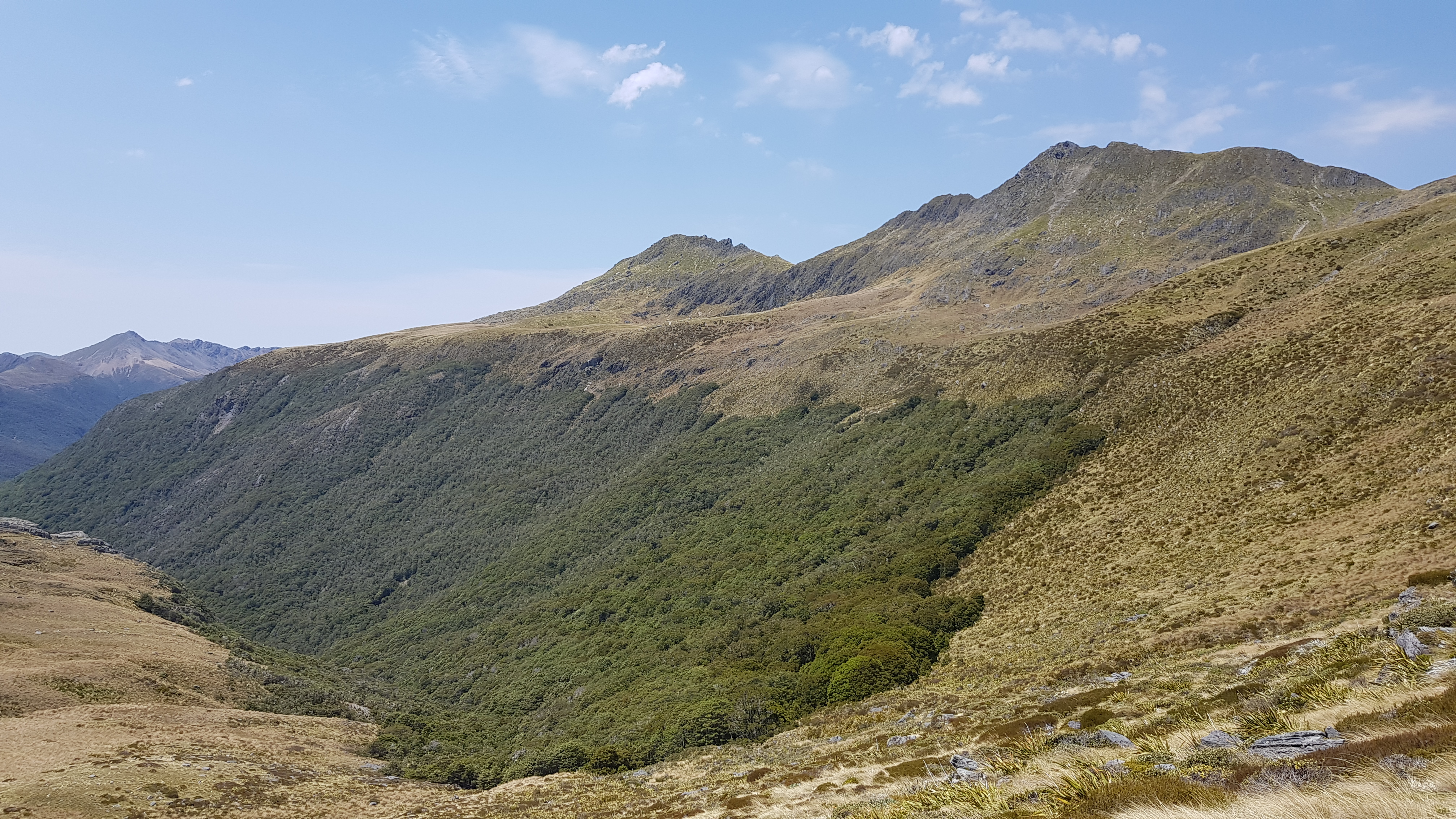
It was super windy, so when we reached the top of the ridge at 1 pm, so we didn’t linger. We admired the spectacular views over more amazing mountains and an unnamed lake and saw some clouds gathering in the distance. We got a phone signal and checked the weather. Rain was now predicted to come in pretty soon, so we pushed on fairly quickly.
Roughly following a contour line of 1400m we sidled the ups and downs beneath Mt Cobb heading back East. In between the long tussock, some parts were pretty rocky. In others, there were large water-filled holes that you’d easily lose a full leg in. Thankfully the next hour or so passed without a hitch, and we kept stopping to marvel at Round Lake and Cobb Lake in the valleys below.
We came to a series of pretty tarns and decided to have lunch around the corner – hoping it would be less windy.


Towards Camp Lake
Having rounded the range to head South it was no less windy, but we managed to find a nice spot tucked away in a little depression where it wasn’t blowing a gale. We stopped for lunch at 2.45 pm. The spot overlooked the Lockett Range and yesterday’s route.


We only had a few kilometres to go, and the weather hadn’t packed in yet, so we enjoyed exploring the upper tops. After lunch, we just had one little steep gully to negotiate, and then it was pretty much downhill to Camp Lake – except we wanted to see Lake Henderson on the other side of the range (some guys we passed this morning had camped there last night).
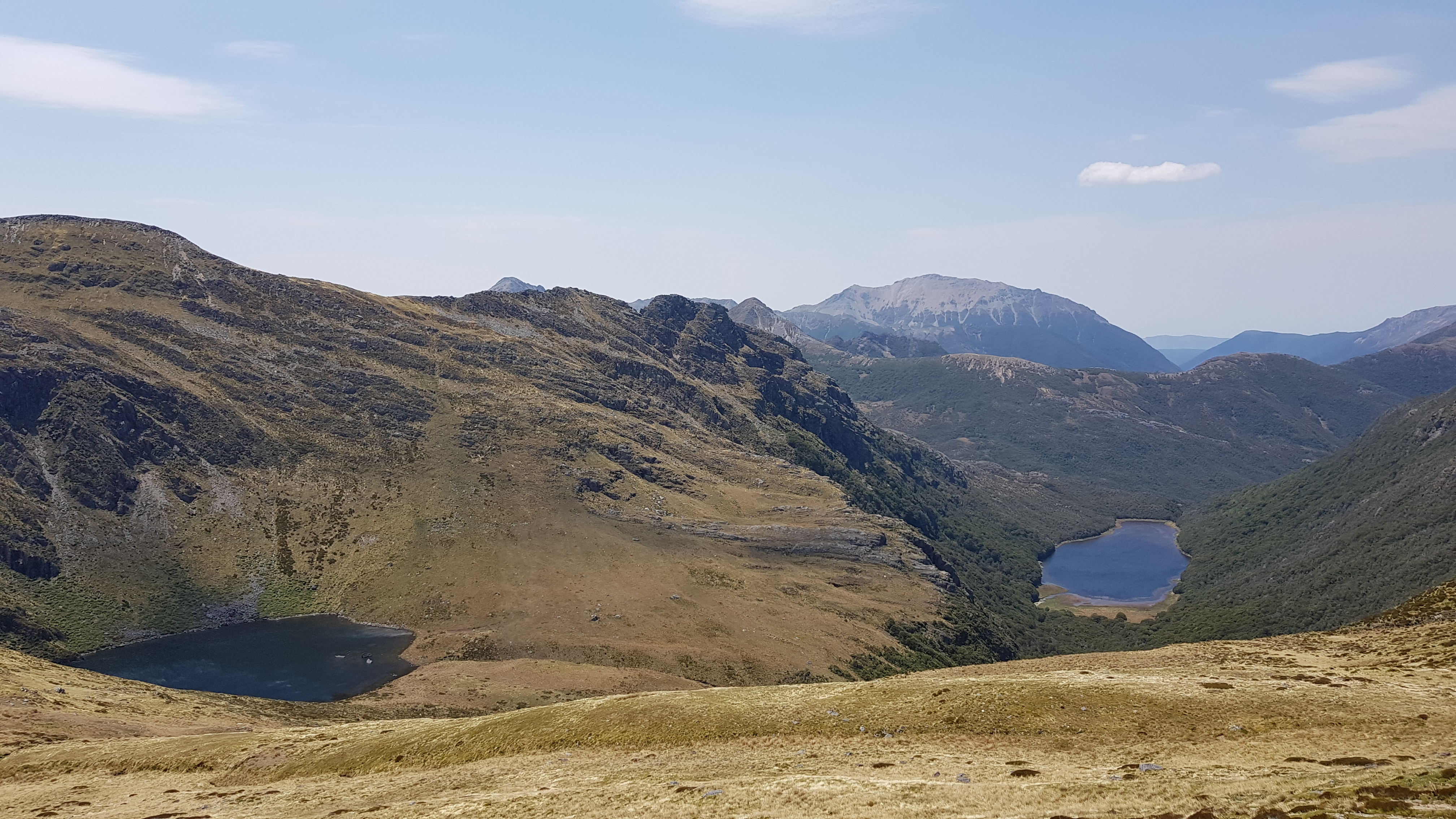
We came to a small spur at 1500m overlooking another tarn and only had a small climb up to a tiny gap on the ridge. We dropped our packs and headed up for a look. The wind was funnelled into a howling gale through the gap, so we got a quick look at the lake before immediately heading back down.
The small tarn below was actually quite a big one. From a distance up on the ridge, we could see some birdlife around it. We suddenly had a random thought that there might be some rare Takahe up here, and made our way down rather excitedly… but actually, it turned out to be a weka family.
Camp Lake was around the next ridge and we continued on through the long tussock. En route, we came across an interesting scientific-looking setup.
Ten minutes later we were overlooking Camp Lake. We followed a taped route through the bush down to the lake and continued on across the lake outlet. Having set up camp on a dry, flat section above the stream and got the water on to boil. We settled into the tent with a hot soup just as it began to rain.

Day 3 – Camp Lake to Tent Camp and out along the Cobb Valley
Our third day was very cruisy, and took us down into Tent Camp in the Cobb Valley, up to Cobb hut (which was too good a bagging opportunity to miss) and out 12 km or so on the flat to Trilobite hut.
It drizzled for most of the night, but we woke to a fine morning. We enjoyed a leisurely breakfast before packing up and heading back up the taped route (that we had come down yesterday) up to the tussock. We retraced our steps and found a couple of cairns. These indicated the start of the taped route down through the bush into the valley. Rich had been this way before, so it was handy to know where to look out for them.
We left Camp Lake at around 9.30 am and were down in the Cobb Valley by 11 am.

Hut Bagging
We arrived in the valley very close to Tent Camp. It is thought to be the only remaining ‘tent camp’ in New Zealand. The excellent information board in the hut told us that tent camps were built in New Zealand from the 1930s when government deer culling began and funding didn’t stretch to building huts.
This one was built in 1973 (and lovingly restored in 2014) using timber poles, with a large canvas stretched over the top. There is even a fireplace! It is definitely worth a visit. The Cobb River was just behind the hut, there was a nice picnic table for lunch and a remarkably decent long drop nearby.

We dropped our packs at Tent Camp and headed back up the valley towards Fenella hut for a couple of kilometres to bag Cobb Hut. Cobb Hut was very cute too. It was a rather more standard if basic, 4-bed hut. The highlight of our visit to Cobb hut was finding a beautiful sketch left there – drawn by hiker Sean Johnson (from Alaska) last year.


We retraced our steps back to Tent Camp and came across a couple of trees with NZ mistletoe in full bloom – something which I had never seen before. It was magnificent! We were back at Tent Camp by 12.30 pm and enjoyed our lunch in the sun.

After lunch, we headed down the Cobb Valley towards the reservoir. We met lots of other trampers including plenty of families. The track following the Cobb River was great – nice and easy, through the bush and beautiful open valley.
The next hut en route was the 3-bed Chaffey Hut – another beauty constructed from timber in 1952-53. It was restored in 2014 by volunteers (1500 hours of labour) and is now maintained by the NZ Deerstalkers Association.

Towards Trilobite Hut and out
It was an easy walk out. We left Chaffey Hut at 2.20 pm and were at the 12-bed Trilobite Hut by 4 pm.

Trilobite hut was busy with people coming and going from their various activities. You can drive right up to it, so was filled with day walkers and families.
Our mission wasn’t quite finished. Well, mine was, but Rich had to find the bike hidden in the bushes. He then biked 30 mins or so back to the car at Sylvester Hut. Thank goodness there was a tailwind. To be honest, Trilobite was so busy we probably would have found a hitch soon enough, but an hour later we had the car back and made our way out of the valley.
I can honestly say that this New Year would take some beating. A beautiful tramp, perfect conditions and opening up so many more possibilities for future adventures.
When we got back to Takaka we cracked a bottle of rose and enjoyed a huge celebratory fish & chip dinner in the evening sun.

Click the links below for some other walks in the area:
- Tableland Circuit – Cobb Asbestos, Salisbury, Peel – overnight
- Tableland Loop – Flora, Gordons, Salisbury, Balloon, Flora – overnight
- Mt Peel from the Cobb – day walk
- Mt Arthur – day walk
- Ellis Basin Route – three days two nights
- Mt Owen Day 1, Day 2 – overnight
- Thousand Acre Plateau – three days two nights
- Anatoki Killdevil Pack Track – three days two nights
- Kahurangi Lighthouse
Lovely photos that reminded me of exploring there several times in the 1980’s – the place looks exactly the same, though Cobb Hut seems to have a fresh coat of paint!